Tropical low to bring wind & rain this week
23/03/2026 12:19am
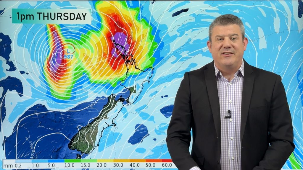
A low exiting the tropics near New Caledonia this week will grow larger in the Tasman Sea and finally bring in much needed rain to dry parts of New Zealand – but not everyone will get the rain they need.
While the low is going to be stormy at sea, it will fall apart as it moves in to the South Island around Friday and Saturday. Heavy rain potential is most likely in the top of both main islands, with driest weather in the south of both main islands.
The low may also interact with the powerful high pressure belt we kick this week off with, creating strong to gale nor’easter this week as the low moves closer, especially at the top of the country.
We bring you the latest tracking and rainfall numbers for the week and weekend ahead – and how Monday next week may kick off.
Comments
Latest Video

Rain & showers this weekend, colder change next week
Some places will warm up over the next day or so as a nor’wester out of Australia moves across NZ,…
Related Articles
Rain & showers this weekend, colder change next week
Some places will warm up over the next day or so as a nor’wester out of Australia moves across NZ,…

Temperature changes for some regions ahead of heavy West Coast rain
A nor-wester is about to kick in and it’s coming from out of Australia, boosting temperatures in some regions going…

NZ 7 day forecast: Showers, temp changes and heavy West Coast rain
NZ has a fairly messy forecast over the next 7 days, but the main feature will be heavy rain on…


BC on 23/03/2026 5:09am
Thanks PD, great intel.