Tropical storm to bring severe weather to NZ, gales & heavy rain
23/03/2026 11:08pm
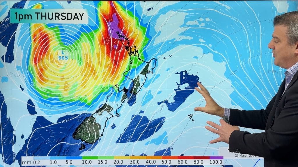
A tropical cyclone is today leaving the tropics and will grow into a larger storm system for a time in the Tasman Sea, before falling apart on Saturday as it moves into the West Coast.
Severe weather risks are most likely in the north of both main islands, but damaging wind gusts may spread nationwide for a time in places most exposed to north-easterly winds. We bring down the latest wind and rain maps – and we do expect to fine tune this further in the coming days.
The tropical cyclone is not a named one by the Fiji Met Service but did reach tropical cyclone status yesteday according to the Joint Typhoon Warning Center (JTWC) which globally tracks tropical cyclones.
MetService has already started issuing weather warnings and watches ahead of this storm.
Not everyone in NZ will have heavy rain and strong winds – we break down which areas also miss out on much of the wet weather.
Comments
Latest Video

Slow moving low to track over northern NZ
A low pressure zone will slowly cross the North Island over the coming days, bringing hit and miss pockets of…
Related Articles
Slow moving low to track over northern NZ
A low pressure zone will slowly cross the North Island over the coming days, bringing hit and miss pockets of…

NI low pressure, SI polar change
Low pressure will move over the upper North Island this week, bringing hit and miss pockets of heavier rain into…

Rain & showers this weekend, colder change next week
Some places will warm up over the next day or so as a nor’wester out of Australia moves across NZ,…


Chris on 24/03/2026 6:52am
How do you get your money / income from producing these valuable weather updates to us?
WW Forecast Team on 24/03/2026 7:00pm
Hi Chris, mainly through advertising – and also those that download our free app, but upgrade to the paid services. 🙂
Cheers
WW
Brendan on 24/03/2026 6:34am
Great info. Thanks for sharing your intel…
WW Forecast Team on 24/03/2026 7:00pm
Our pleasure, thanks for the thanks Brendan 🙂
– WW
Wayne on 24/03/2026 2:33am
Phil! Thanks again for the update on the depression about to hit the Nth Island on Thursday. Looks like the Eastern side of the Nth Island side gets let off most of the rain?
WW Forecast Team on 24/03/2026 7:01pm
Yes apart from Northland and Coromandel Peninsula, those south of Gisborne in the east won’t get a huge amount from this event based on the latest data.
– WW