March Madness: Tropical Cyclone URMIL, a cold change and a ‘mountain range of high pressure’
26/02/2026 11:17pm
March often brings in some wild changes in our weather – and we do have both a tropical cyclone north of NZ and a brief polar southerly moving up eastern NZ as we go into Sunday and early next week. But despite those big systems, the main feature of New Zealand’s weather over the coming week will be mostly high pressure and drier skies.
In fact by the middle to later part of next week one anticyclone centred east of NZ may stretch from Sydney, over the Tasman Sea and NZ, out past the Chathams and the International Date Line and extend almost 7000km across from west to east. It’s like a mountain range of high pressure it’s so large.
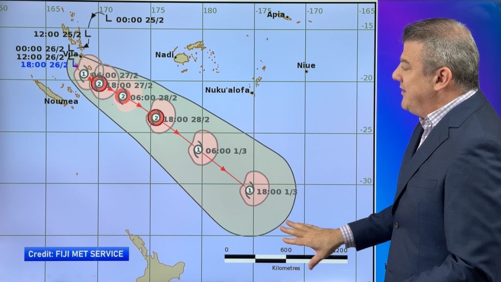
The tropical cyclone near Vanuatu has now formed (as of Friday Feb 27) – but at the time of recording this it was yet to be officially named by the Fiji Met Service. On Friday afternoon it was officially named Tropical Cyclone URMIL.
We’ve done some research and from what we can see this is the South Pacific’s latest ever first named tropical cyclone. The previous latest first named storm to develop was Cyclone Bart on Feb 21st in 2017. The cyclone season started back on November 1st, 2025.
The Fiji Met Service expects Cyclone Urmil to remain mostly at sea and to reach Category 2, with air pressure down to about 970hPa at the centre.
The tracking of this tropical cyclone does carry it over NZ waters, but it should remain far enough from land to not affect our weather significantly, but it is in a position to definitely keep an eye on.
Comments
Latest Video

Wintry burst of weather: Snow, squally showers then sunshine & frosts
A polar change (another one!) arrives on Friday for the South Island and goes nationwide on Saturday, leaving NZ under…
Related Articles
Wintry burst of weather: Snow, squally showers then sunshine & frosts
A polar change (another one!) arrives on Friday for the South Island and goes nationwide on Saturday, leaving NZ under…

Antarctic southerly for parts of NZ Fri & Sat
For the first time this year a southerly from off Antarctica is heading towards the South Island, followed by more…

Meteors – Your Eyewitness Reports!
WeatherWatch.co.nz receives meteor reports from all over New Zealand and the globe, 24/7/365. **CASUAL COMMENTS**If you’ve seen something in the…


Ron Mario on 27/02/2026 7:06pm
From Fiji,
I like how he explains the weather map clear even the simplest person can understand.