Extreme Tasman Sea storm to blast Australia and drench New Zealand (+15 Maps)
9/05/2018 11:15pm

> From the WeatherWatch archives
Extensive Coverage — A significant storm is developing in the Tasman Sea and will bring extreme conditions to the south eastern side of Australia while drenching parts of New Zealand too.
There’s a lot to cover so we’ll keep Australia and New Zealand weather separate and in bullet points below.
In a nut shell the main storm centre will hug the south eastern Australian coastline for a number of days bringing repetitive severe weather. New Zealand is on the calmer side although strong winds may also affect various parts of the country on Friday and this coming weekend. However New Zealand’s main threat may be coming from sub-tropical northerlies bringing very heavy rain and possible slips and flooding this weekend – meanwhile Australia has the colder southerly on the other side of the low which could bring snow to their ranges and mountains.
AUSTRALIA WEATHER HIGHLIGHTS
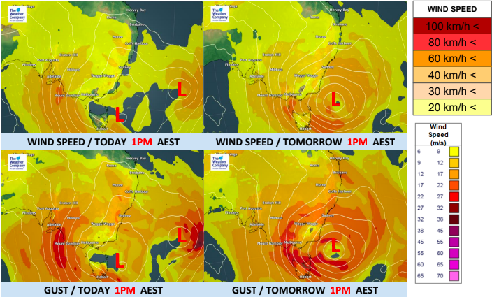
- The low near Tasmanian will develop further today and Friday and another trough will approach Victoria today.
- The air pressure gradient behind the low pressure will be stronger therefore strong winds of 30-40 km/h are expected in the south coast of South Australia and Victoria.
- Wind gusts may reach 80km/h in some areas.
- The low pressure will be blocked in the Tasman Sea Friday, Saturday and Sunday and will almost stay in the same location, feeding miserable weather in for days.
- The areas of strong winds will expand eastward and it will be averaging 30-40 km/h in the coastal areas of Victoria and New South Wales.
- Wind gusts will reach above 60km/h in many areas and may be above 80km/h near Melbourne.
- Some gusts may be in excess of 100km/h and may cause damage in wind tunnels nearest to the south east coastline.
- Dangerous surf and high waves of about 5m will also be possible.
- Friday night, it will move north a little and deepen more.
- The main areas of severe weather will also shift from the south coast to the east coast this weekend.
- Moist air from the sea will flow and give heavier rain in the east coast of Victoria.
- Total rainfalls may reach 300-400mm in the national park between Sale and Canberra.
- There are big threats of mudslides and flooding Friday night until Saturday.
- The low will continue to move northward slowly in the Tasman sea.
- Threats of heavy rain will gradually dissipate this weekend.
- However, threats of strong winds will continue in the east coast of Victoria and New South Wales.
- Gales with high waves are expected in the east coast, near Sydney.
- The storm will bring cooler trends through the weekend.
- Snow may fall over mountains, above 1000m heights, in Victoria and the Tasman island.


NEW ZEALAND:
Being further away from the centre of this storm means New Zealand won’t have to deal with the same extreme conditions but a secondary low today and tomorrow may produce some heavy rain and pockets of strong winds in New Zealand.
The main threat for New Zealand is this weekend in the upper half of the North Island as very heavy bands of rain slowly track eastwards.
NEW ZEALAND WEATHER HIGHLIGHTS:
- Rain is falling on the West Coast today.
- A storm in the Tasman Sea will very slowly approach New Zealand Friday.
- It will rain in both islands (mainly the South Island) and locally there could be 100-150mm on The West Coast.
- There are risks of slips and localised flash floods.
- For a time strong winds are expected in most areas and will be averaging 20-30 km/h, gusting about 60 km/h (near gale force) but this is mainly around the Cook Strait area.
- Warmer air will flows from the north, so warmer rain will fall in most areas until tomorrow.
- Snow may only fall to 2000m in the South Island due to the sub-tropical airflow in many regions.
- This weekend converging sub-tropical winds (nor’westers from the Tasman Low and nor’easters from the departing high) will create a very heavy (potentially torrential) narrow slow moving band of rain which will cross over the northern half of the North Island from Saturday PM to Monday AM at this stage.


 – Friday 10am shows the small secondary area of low pressure approaching the West Coast of New Zealand while the main storm centre remains on the other side of the Tasman Sea, hugging the Australian coastline.
– WeatherWatch.co.nz – Proud to be an official IBM/TWC business partner
Latest Video

Polar airflows set to bring cold weekend to NZ
Nor-west winds will be building over parts of NZ going into Thursday with rain on the West Coast becoming heavy…
Related Articles

NZ: Cold & windy, then calm & frosty
Downpours, some squally with the chance of thunderstorms and even small tornadoes are possible for parts of NZ over Friday…

WeatherWatch App launches real-time local lightning tracker
A bolt out of the blue! WeatherWatch has launched a live, real-time lightning tracker, enabling Kiwis to gain access to data provided by the…

Wind, rain, showers & a noticeable temperature drop for all
It will be a colder weekend right across NZ as a sub-Antarctic southerly blows through, bringing frosts, snow flurries and…

