Cyclone Gretel likely to brush northern NZ but should remain offshore (+12 Maps)
14/03/2020 10:36pm

> From the WeatherWatch archives
Cyclone Gretel was named overnight by Australian forecasters as it deepens over the Coral Sea.
The storm is not currently expected to make landfall anywhere but will brush New Caledonia, Norfolk Island and northern New Zealand.
While computer modelling usually shows storms moving in a line they do wobble a lot, meaning that although modelling today is even further in agreement that Gretel will likely remain just offshore, there is still that risk it could ‘wobble closer our way’ at the last minute.
However, as we’ve said for a week now, the building high pressure zone in the Tasman Sea will be the guiding force for Gretel, with the high most likely protecting much of NZ. Severe weather with cyclones is usually within a few hundred kilometres of the centre of the low – so if the storm stays more than a few hundred kilometres offshore so too does the severe weather. If the cyclone moves a little closer, the severe weather comes with it.
This cyclone is not a ‘fizzer’ as New Zealanders often say when a storm doesn’t hit them. In this case there is a serious storm with damaging hurricane force winds sliding past NZ, not falling apart before it gets here. It’s like someone shooting a bow and arrow and it only slightly missing the target. It’s still serious to be close to it as it comes towards us.
On Monday WeatherWatch will be able to fine tune if any severe weather will brush NZ. At this stage it’s still looking mainly offshore but that could change within the next 36 hours. There will be some pockets of severe weather as you can see in the maps below. You can also track tax funded MetService for warnings as the storm leaves Australia’s control on Monday.
While Gretel will be technically downgraded before it reaches the NZ area it will likely retain Category 1 or 2 equivalence as it narrowly tracks past Northland to the north east.
Gretel is currently producing 10 metre waves at sea and will make for dangerous marine and beach conditions in northern and north eastern New Zealand from Monday to Wednesday.
Gale force winds over 100km/h are most likely around the north eastern North Island (East Cape and Gisborne ranges, eastern Bay of Plentry). Watch for possible wind warnings.
With the storm likely to be offshore there is less rain expected in drought affected Northland. These totals may still change so refer to your local hourly and 10 day rainfall totals in your WeatherWatch forecast for more details over the coming days.
WHAT THE MODELLING SAYS FOR TUESDAY MORNING:
GFS (America):

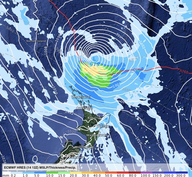
ECMWF (Europe):
BoM TRACKING:

JTWC (USA) TRACKING:
IBM / WeatherWatch maps:


WeatherWatch.co.nz
Latest Video

Colder nights/mornings, polar change coming Sun/Mon
The nights and mornings ahead will be colder in a number of regions – but an even colder change is…
Related Articles
Colder nights/mornings, polar change coming Sun/Mon
The nights and mornings ahead will be colder in a number of regions – but an even colder change is…

Frosts, clearer skies coming – severe weather possible this weekend
High pressure lies south of NZ today and that placement encourages a colder south-east wind into the North Island bringing…

NZ: 8 Day outlook as gales & rain ease, high pressure builds
Damaging wind gusts and heavy rain will continue to affect some parts of the North Island and brushing Marlborough today…

