ClimateWatch: November’s outlook + Dec/Jan as La Nina looms (+12 Maps & Video)
31/10/2021 9:57pm

> From the WeatherWatch archives
We’re getting closer to summer and getting closer to La Nina likely influencing our weather patterns a little more.
WeatherWatch.co.nz says a ‘moderate’ La Nina looks likely to impact the South Pacific and Australian weather patterns in the months ahead and November gets a taste of this with easterlies dominating and weekly rainmakers moving through the NZ area.
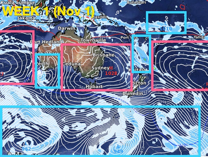
The South Island is looking more spring like with a few cooler southerlies in the mix but also plenty of big highs keeping eastern areas drier than usual.
WeatherWatch.co.nz says NZ’s location on earth means that while we are influenced by La Nina we’re also half way to Antarctica from the tropics, so the Southern Ocean storms and westerly flows can still impact NZ and this sometimes pushes La Nina weather patterns aside from time to time.
LA NINA
Scientists at Australia’s Bureau of Meteorology (BoM) say there is a 70% chance of La Nina forming this summer. La Nina is when sea surface temperatures (SST) are warmer than average in the western Pacific’s tropical zones. Warmer sea surfaces encourage more humidity, cloud and rainmakers into the NZ area from the north.


WEATHER PATTERNS FOR NOVEMBER:

UPCOMING RAINFALL:

Red = Drier than average. White = About normal rainfall. Blue = Wetter than usual.

Very dry for the eastern South Island with perhaps as little as 1 to 5mm over the coming 16 days.
Meanwhile, the north eastern North Island could have 50 to 100mm in that same time period.
The most accurate rainfall totals for you locally can be found at www.RuralWeather.co.nz or check the hyper-local daily totals at WeatherWatch.co.nz

White = Average
Yellow/Orange = Leaning a little drier than average

Green = Normal rainfall or possibly slightly above normal
White = Average
Yellow/Orange = Leaning a little drier than average

Green = Normal rainfall or possibly slightly above normal
White = Average
Yellow/Orange = Leaning a little drier than average

North Island leans 0.5 degrees above normal.
South Island leans 0.8 degrees above normal.

Cloud cover and more wet weather in Aussie will pull down their temperatures by as much as -0.7 through inland NSW.
These exclusive ClimateWatch updates are a WeatherWatch.co.nz product — brought to you by www.RuralWeather.co.nz and our business partners at IBM.
Latest Video

Frosts, clearer skies coming – severe weather possible this weekend
High pressure lies south of NZ today and that placement encourages a colder south-east wind into the North Island bringing…
Related Articles
Frosts, clearer skies coming – severe weather possible this weekend
High pressure lies south of NZ today and that placement encourages a colder south-east wind into the North Island bringing…

NZ: 8 Day outlook as gales & rain ease, high pressure builds
Damaging wind gusts and heavy rain will continue to affect some parts of the North Island and brushing Marlborough today…

Pockets of hit & miss heavy rain, snow moves northwards
Low pressure continues to slowly move across the upper North Island and for some that will bring the sun out,…

