ClimateWatch: How June is shaping up + Winter’s expected rainfall in NZ (+11 Maps)
1/06/2021 6:54am

> From the WeatherWatch archives
Hard to believe we’re entering the halfway mark of 2021 already but here we are in June and the start of winter on the meteorological calendar (Winter also starts June 21 on the astronomical calendar).
La Nina ended back in Autumn and the weather pattern around New Zealand and Australia remains a ‘neutral’ one – which increases the chances of a chaotic pattern with pockets of extremes (as we just saw with the flooding in Canterbury but fairly dry further north).
As we go through June it’s clear the chaotic pattern continues with far more low pressure in the mix – although the few highs that are still around will still impact NZ bringing settled periods, especially northern and eastern areas. This is good news for Canterbury – but not good news for Hawke’s Bay still dealing with drought like conditions.
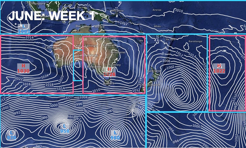
HOW THE AIR PRESSURE ZONES ARE SHAPING UP THIS JUNE…

UPCOMING RAIN…

Red = Drier than average, White = Normal rainfall, Blue = Wetter than usual

White boxes highlight areas with low rainfall (ie, less than 10mm)

You can see how heavy rain leans to the west and north of NZ – but eastern areas still look fairly dry overall.

TEMPERATURES…


LA NINA? EL NINO? No – it’s just neutral for now…


To drill down much more on a local level – please visit www.RuralWeather.co.nz – it’s NZ’s largest weather data website for your local area.
Comments
Latest Video

NZ: 8 Day outlook as gales & rain ease, high pressure builds
Damaging wind gusts and heavy rain will continue to affect some parts of the North Island and brushing Marlborough today…
Related Articles
NZ: 8 Day outlook as gales & rain ease, high pressure builds
Damaging wind gusts and heavy rain will continue to affect some parts of the North Island and brushing Marlborough today…

Pockets of hit & miss heavy rain, snow moves northwards
Low pressure continues to slowly move across the upper North Island and for some that will bring the sun out,…

Slow go for northern low & southern cold
For the next few days low pressure will crawl over the upper North Island, driving in rain as far south…


Nick on 1/06/2021 6:30pm
As June 21st is the shortest day, why is June considered the first month of winter rather than a more symmetrical; May, June July?
WW Forecast Team on 1/06/2021 7:44pm
Hi Nick, this story from 2017 covers what you’re asking about (although it’s focused on the end of winter – but it’s the same topic). Hope it’s helpful: https://www.weatherwatch.co.nz/content/did-you-know-there-are-4-different-end-dates-to-winter
Cheers
Phil
Jan Lawrence on 1/06/2021 8:22am
Very hard to make out NZ beneath all those isomers etc. Is there some way to make the outline bolder? A different colour maybe?
WW Forecast Team on 1/06/2021 7:46pm
Hi Jan, we don’t have much control over those maps, but if you can generally see where NZ is that’s all that matters for these updates as they are not about local regional weather in NZ (we’re just too small for these big picture updates – so it’s more about the general highs and lows and how they will impact our part of the globe. But we will see if we can highlight NZ in any better ways next time.
Cheers
Phil D