Weather headlines (x3) for Thursday: Thunderstorms in the west, Some regions warm today, Frosty SI Sat morning
1/06/2022 7:00pm

> From the WeatherWatch archives
Here’s what is making the weather headlines today.
THUNDERSTORMS AGAIN IN THE WEST
An unstable westerly quarter airflow lies over the country today and that means thunderstorms for western regions, the western North Island in particular is in the firing line as a front moves through this morning / around midday then a trough towards midnight.
Check out more on the latest thunderstorm risk here.


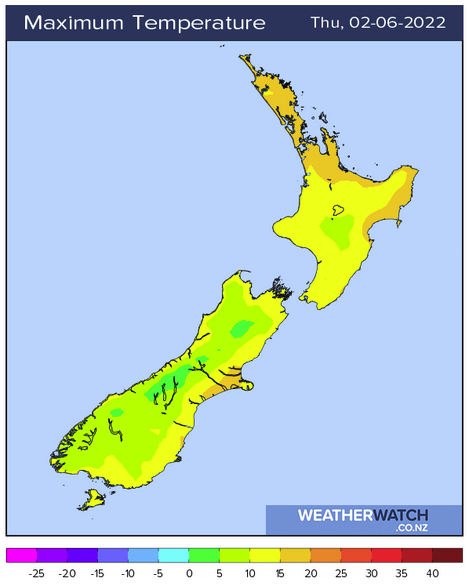
WARMEST EASTERN SOUTH ISLAND AND HAWKES BAY / GISBORNE
The eastern South Island has a fairly good day weather wise despite quite a bit of unsettled weather around the country, Canterbury for example has some sun and high cloud with a high around 17 to 18 degrees. Hawkes Bay and Gisborne has temperatures getting into the late teens or early twenties however as a front pushes over the North Island rain will start spreading from the west afternoon on wards at which point temperatures will cool off a little.
In all honesty Hamilton northwards sees temperatures in the late teens too however a fair chunk of the day is going to be wet.
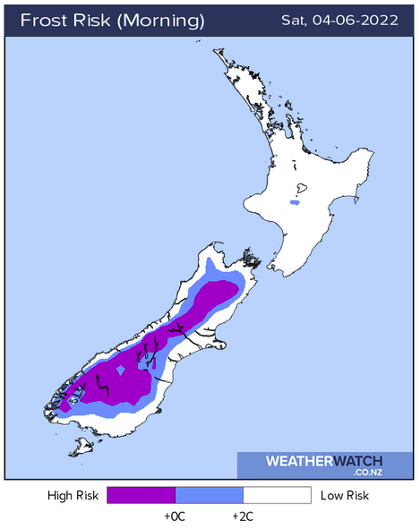
FROST SATURDAY MORNING
High pressure starts to move in overnight Friday so Saturday morning for the South Island will likely see frosty conditions. More on the frost risk coming up here.
Latest Video

Snow, rain showers & cold polar southerlies set to return
Friday will be a wintry day across NZ as the next cold front arrives, bringing snow to lower levels of…
Related Articles
Snow, rain showers & cold polar southerlies set to return
Friday will be a wintry day across NZ as the next cold front arrives, bringing snow to lower levels of…

Frosts, late week rain & another cold weekend coming
High pressure will cross NZ over the next few days meaning more cold nights/mornings with frosts, but a nor’wester will…

NZ: Cold & windy, then calm & frosty
Downpours, some squally with the chance of thunderstorms and even small tornadoes are possible for parts of NZ over Friday…

