Tracking the windy & wet weather, then the next anticyclone
28/12/2025 11:36pm
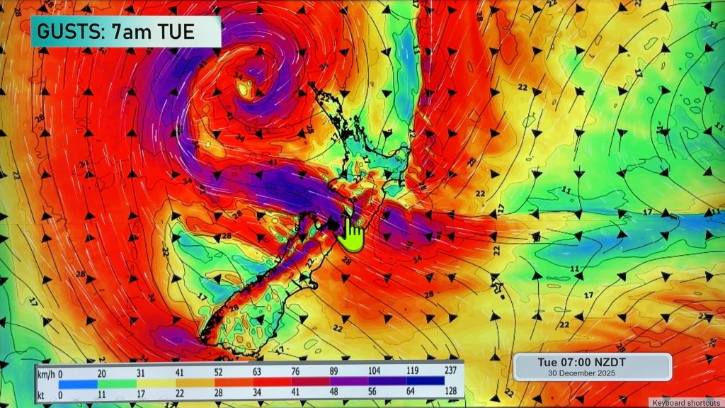
A depression west of the upper North Island is helping bring rain and strong winds to parts of New Zealand, today, tonight and into Tuesday. Generally speaking the wind and rain is tracking down the North Island and will stop around the upper half of the South Island as high pressure grows in the south.
We track the movement of the windiest weather, and which areas are most exposed to rain – but we also take a look at when the winds ease and drier weather comes in.
New Year’s Eve looks look intense weather-wise, but with low pressure in the area it’s going to spark some daytime and early evening downpours and thunderstorms, especially around the western and upper North Island.
New Year’s Day sees much larger dry areas and the winds easing further for most, although may still be a little windy in some spots – our video explains more. Still more daytime downpours and possible thunderstorms.
This weekend an anticyclone (high pressure) finally looks to move in over the country, and while cloudy weather and some showers may still be possible many other places should be sunnier and hotter.
Our next weather video will be tomorrow/Tuesday.
Comments
Latest Video

Low pressure heading to NZ this weekend & into next week
Many regions have settled weather at the moment with frosts as far north as Auckland this morning, but still some…
Related Articles
Low pressure heading to NZ this weekend & into next week
Many regions have settled weather at the moment with frosts as far north as Auckland this morning, but still some…

Colder nights/mornings, polar change coming Sun/Mon
The nights and mornings ahead will be colder in a number of regions – but an even colder change is…

Frosts, clearer skies coming – severe weather possible this weekend
High pressure lies south of NZ today and that placement encourages a colder south-east wind into the North Island bringing…


Absolutely on 29/12/2025 6:24am
Absolutely disgusting weather we’re getting served up short changed summer
millsy on 29/12/2025 10:22am
Correct. It is supposed to be summer, and we have been getting total garbage weather. Needs something done.
Jacques on 29/12/2025 7:13pm
Suppose it depends where you are for summer. Where I am right now it’s sunny and warm