Sunday’s forecast – fairly settled ahead of severe weather for some by Monday (+7 Maps)
9/10/2021 3:00pm

> From the WeatherWatch archives
Sunday will be pretty settled across NZ although some wet weather lingers in eastern parts of the North Island in particular, while clouds build in the south west ahead of the next rain band.
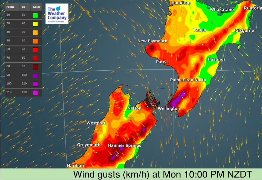
The incoming rain band on Monday and Tuesday will be active – by that we mean heavy downpours, a chance of thunder, fast moving and it brings with it much colder air behind it. This active rain band will bring in some low pressure which will then deepen significantly off the eastern coastline of the South Island over Tuesday and Wednesday – driving in coastal gales to the east. This is why this low could also be classed as a ‘storm’.
To drill down deeper see your HOURLY details at both WeatherWatch and RuralWeather.co.nz.
NEW MAPS: Air pressure + Rainfall: https://www.weatherwatch.co.nz/maps-radars/rain/rainfall-and-pressure
NEW RADAR: WeatherWatch.co.nz and RuraWeather.co.nz (and soon our WeatherWatch App) now all have LIVE Rain Radar: Bookmark this page showing the latest real-time radar image at the same time as MetService receive it: https://www.weatherwatch.co.nz/maps-radars/radar/rain-radar-realtime
Joint MetService–WeatherWatch Media Release: “MetService and WeatherWatch put closer relationship on the radar“
We’ll have another update before noon Sunday with updated maps and details – and more specifics on places most impacted.


Latest Video

Antarctic southerly for parts of NZ Fri & Sat
For the first time this year a southerly from off Antarctica is heading towards the South Island, followed by more…
Related Articles
Antarctic southerly for parts of NZ Fri & Sat
For the first time this year a southerly from off Antarctica is heading towards the South Island, followed by more…

Meteors – Your Eyewitness Reports!
WeatherWatch.co.nz receives meteor reports from all over New Zealand and the globe, 24/7/365. **CASUAL COMMENTS**If you’ve seen something in the…

Snow, rain showers & cold polar southerlies set to return
Friday will be a wintry day across NZ as the next cold front arrives, bringing snow to lower levels of…

