Major rain relief reaches Australia, but NZ’s outlook more complicated for now (+5 Maps)
7/02/2020 6:57pm

> From the WeatherWatch archives
Real rain is arriving in Australia – a deluge big enough to extinguish major bush fires. But dry New Zealand has a longer wait.
It’s a straight forward set up for eastern Australia this weekend, but for New Zealand the forecast is made more complicated due to extra high pressure in the area.
“It’s a significant positive sign to see rain arrive back in eastern Australia like this. The positive for New Zealand is that if we caught the same dry they have, we may also get their rain in time too’ says WeatherWatch.co.nz head forecaster Philip Duncan. “An ex tropical cyclone may help bring further rain to eastern Australia next week, after it forms in the Coral Sea this weekend. The future of that low may see NZ getting rain too”.
Parts of New South Wales will get a staggering 400mm near the coast over the weekend, which will almost certainly lead to some flooding – but will also put out fires and bring major relief to years-long-drought further inland.
But long range data isn’t yet locked in for New Zealand – and high pressure stuck over drought stricken parts of the North Island means it’s unclear yet if any rain from Australia will actually get into northern NZ. “We often think of a tropical storm or cyclone as coming in to NZ’s north first, but as we’ve seen in recent years these big tropical rainmakers can miss the North Island entirely and bring heavy rain to the West Coast of the South Island instead. One computer model suggests that is likely, others say the North Island does have some chance, but with limited totals due to high pressure being stuck in the area”.
Either way, WeatherWatch.co.nz isn’t ready to confirm rain for the North Island yet – but as we’ve been saying since late January, we believe the middle to later part of February offers some of the better chances for northern NZ rain due to the tropics waking up. There may be an even bigger tropical storm later in February directly north of NZ – or at least another chance of tropical low pressure pulling rain southwards.
It’s important to note that drought conditions are likely to get worse before they get better in New Zealand – but relief may still be on the way. We’ll give another detailed update on Monday – including more info on the potential of a second tropical cyclone this month north of NZ.

FORECAST RAINFALL ACCUMULATION TO FEB 17 (ECMWF)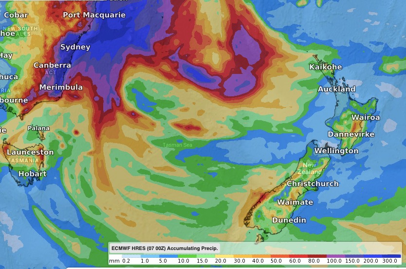
FORECAST RAINFALL ACCUMULATION TO FEB 17 (GFS)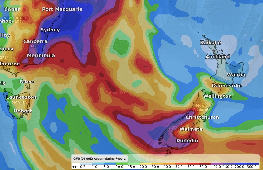
RAINFALL ACCUMULATION ESTIMATE TO FEB 24 (GFS)
NEXT 7 DAYS RAINFALL COMPARED TO USUAL RAINFALL FOR THIS TIME OF YEAR:
Red = Drier than average. White = Normal rainfall. Blue = Wetter than usual.
– WeatherWatch.co.nz
Latest Video

Westerlies continue, sub-tropical for some
West to north-west winds blow through the South Island and lower North Island today bring heavy West Coast rain and…
Related Articles
Westerlies continue, sub-tropical for some
West to north-west winds blow through the South Island and lower North Island today bring heavy West Coast rain and…

Westerly change this week, unsettled but large dry areas
Westerlies kick back in again this week which will bring a break to those in the east as far as…

Matariki, the long weekend + the outlook for next week
Wet weather and cloud continues along the eastern side of the country with the heaviest rain now moving into northern…

