Ex-Tropical Cyclone Uesi reaches NZ on Sunday – latest rainfall totals, gusts, swells (+9 Maps)
14/02/2020 9:29pm

> From the WeatherWatch archives
WeatherWatch.co.nz has the latest rainfall outlook for the next few days across the country as ex-cyclone Uesi moves in to the South Island.
Using high resolution data from IBM, WeatherWatch.co.nz expects rainfall totals of 150mm on the West Coast, which may mostly fall within 24 hours from Sunday into Monday. However, this total may significantly increase if the storm slows down even a little, so be prepared. Keep up to date with official tax funded warnings from Government forecaster, MetService.
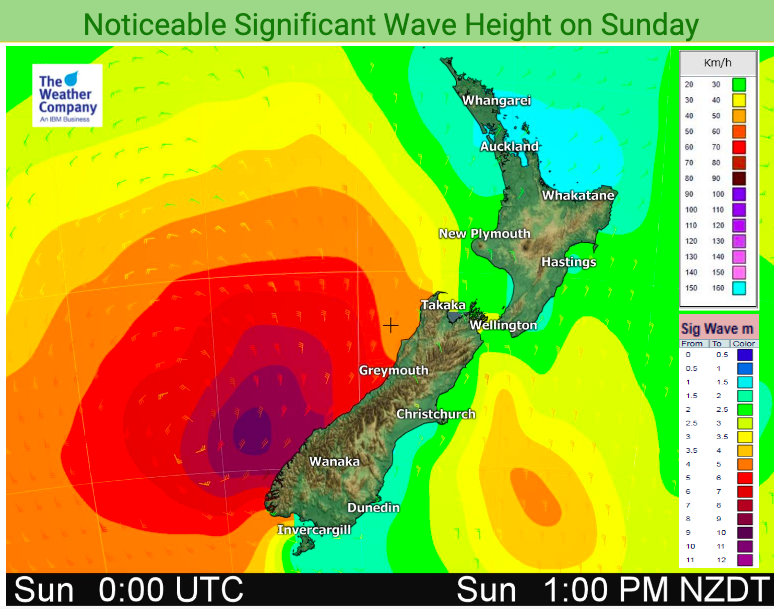
Swells on the West Coast will pick up today and cloud thickens across the country.
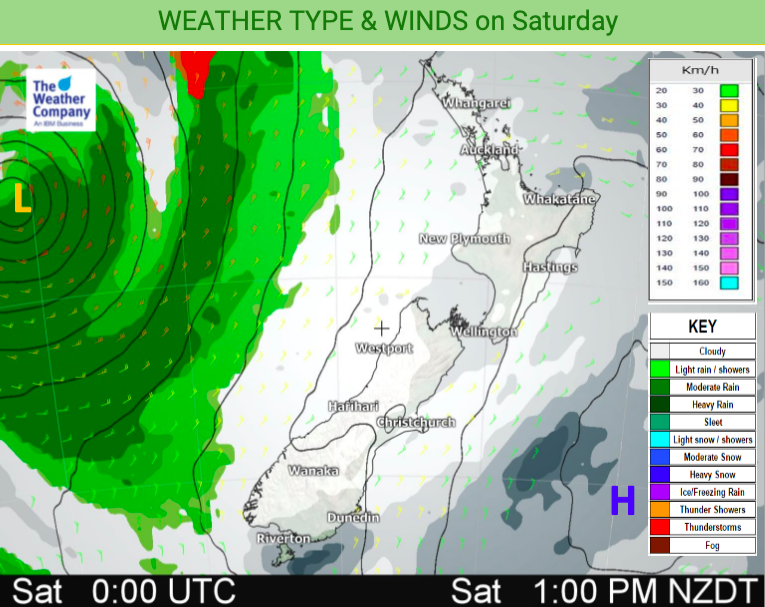
The North Island is cloudy today but will remain dry. The more humid east to north east set up has turned blue skies grey coupled with cloud from Uesi as it tracks southwards across the Tasman Sea.
WeatherWatch.co.nz also says winds could be up and over 140km/h in the mountains/Southern Alps for a time as Uesi’s remnants move in, but 40 to 80km/h looks more likely for most areas lower down towards sea level. Again, keep up to date with any official wind warnings.
Waves of 6 to 9 metres will slam parts of the West Coast, along with storm surge it makes this extremely dangerous and people should stay out of the water and away from river mouths next few days on the western side of the South Island, especially the lower half of the island.
Fiordland National Park and Westland are most exposed to this storm – with surrounding regions also exposed to some severe weather. Trampers and hikers should take extreme care next 72 hours and follow advice from local authorities.
For HOURLY and DAILY graphs and detailed data – all currently for free – check out New Zealand’s largest open weather data site at www.RuralWeather.co.nz (it may take several seconds to load all data first time you visit if you have slower connections – we’re working on a fix for this soon)
SATELLITE: SUNRISE OVER THE TASMAN SEA ON SATURDAY MORNING (9AM NZT) CAPTURES UESI’S REMNANTS SWIRLING AROUND:


– WeatherWatch.co.nz for news, maps & video, www.RuralWeather.co.nz for the most weather data in NZ
Latest Video

Frosts, clearer skies coming – severe weather possible this weekend
High pressure lies south of NZ today and that placement encourages a colder south-east wind into the North Island bringing…
Related Articles
Frosts, clearer skies coming – severe weather possible this weekend
High pressure lies south of NZ today and that placement encourages a colder south-east wind into the North Island bringing…

NZ: 8 Day outlook as gales & rain ease, high pressure builds
Damaging wind gusts and heavy rain will continue to affect some parts of the North Island and brushing Marlborough today…

Pockets of hit & miss heavy rain, snow moves northwards
Low pressure continues to slowly move across the upper North Island and for some that will bring the sun out,…

