Ex-cyclone Uesi will still be a storm when it reaches NZ (+8 maps)
14/02/2020 12:20pm

> From the WeatherWatch archives
Uesi isn’t a tropical cyclone anymore but change to the structure of the low pressure system does not mean that its power is weakening soon. In fact the storm is still likely to bring intense rain for a time, a burst of gales and dangerous seas. Air pressure isn’t likely to change much between today and Sunday.
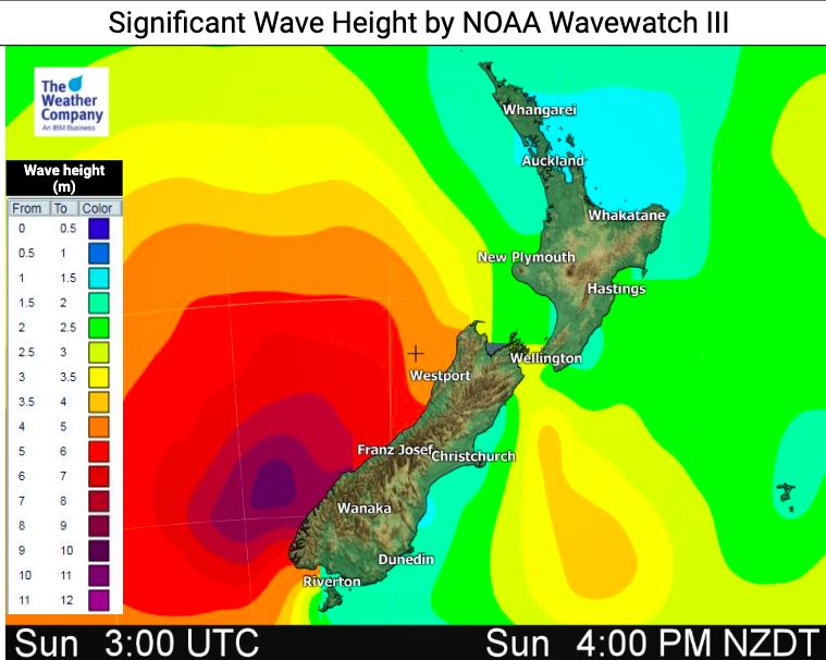
The biggest positive is that much of the storm will likely stay at sea with only part of it hitting the South Island – but enough to dump 150mm of rain in 24 hours on the West Coast and bring waves of up to 8 metres there too.
As of 8:30am Friday Uesi was passing directly over the top of Lord Howe Island.
Storm surge and large waves have the possibility to cause coastal erosion and possibly cause some coastal flooding, especially around rivers from later Sunday into Monday.
The extratropical cyclone will reach the west of the South Island on Sunday while almost retaining its ‘tropical’ power, bringing heavy rain along the west coast for 24 hours and will be closest to the southwest coast late Sunday night before sliding southwards on Monday.
Rain and dangerous beaches on the western side of the South Island look to be the main focus of ex-Cyclone Uesi.


– WeatherWatch.co.nz
Latest Video

29/06/2026 12:30am
Frosts, clearer skies coming – severe weather possible this weekend
High pressure lies south of NZ today and that placement encourages a colder south-east wind into the North Island bringing…
Related Articles
29/06/2026 12:30am
Frosts, clearer skies coming – severe weather possible this weekend
High pressure lies south of NZ today and that placement encourages a colder south-east wind into the North Island bringing…

26/06/2026 12:12am
NZ: 8 Day outlook as gales & rain ease, high pressure builds
Damaging wind gusts and heavy rain will continue to affect some parts of the North Island and brushing Marlborough today…

25/06/2026 12:15am
Pockets of hit & miss heavy rain, snow moves northwards
Low pressure continues to slowly move across the upper North Island and for some that will bring the sun out,…

