(Ex-Tropical) Cyclone Dovi approaching the North Island, severe weather risks for Sunday (+Maps & Animation)
12/02/2022 3:39am

> From the WeatherWatch archives
4:41pm Saturday — (Ex-Tropical) Cyclone Dovi remains on track to directly hit the North Island on Sunday, as it slowly falls apart exiting the tropics. As of 4:15pm Dovi was centred 515km WNW of Cape Reinga and tracking south eastwards towards the western North Island.
DAMAGING WINDS
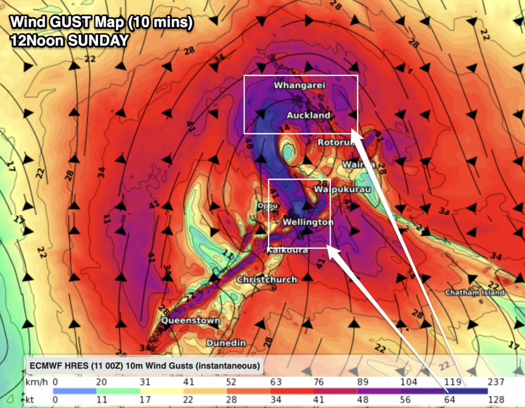
Dovi has the potential to bring widespread damaging gales right around the North Island, including in our largest city Auckland. WeatherWatch.co.nz says those in Auckland should be prepared for a windy Sunday. “Winds over 100km/h can damage vegetation which can therefore impact powerlines and even property. People should ensure mobile devices are charged tonight and outdoor items put away or tied down” says head forecaster Philip Duncan.
Gusts in Auckland may exceed 130km/h in some areas, with peak westerly winds likely kicking in on Sunday afternoon. Over the coming hours we’ll continue to fine tune the Auckland forecast for Sunday.
The strong winds will circle the entire North Island with Dovi’s centre likely to make landfall somewhere around Waitomo (or between Taranaki and Waikato). Where the centre directly tracks helps makes sense of where severe weather will be elsewhere – but the more Dovi moves in and across NZ the less important the centre becomes as it starts to unravel.
“Once a cyclone becomes extra-tropical the severe weather in the middle shifts out to the edges and this process almost always happens when they reach the NZ area, so that’s why you hear a lot of forecasters saying ‘things may still change’ as far as precisely who is impacted – and who may not be”.
Damaging winds may affect Wellington, Marlborough Sounds, Taranaki, Waikato, Auckland, Northland and later on Wairarapa and exposed coastal Hawke’s Bay (and of course those bordering these regions).
If Dovi weakens faster then that will significantly reduce wind damage – but if it retains strength there is a chance for widespread power outages and wind damage. We will UPDATE the risks to Auckland and other main centres later on Saturday.
Not everyone in the North Island will have strong winds, but there’s a significant risk factor across many regions for on Sunday.
MetService has a number of watches and warnings out – you can track them LIVE here.
HEAVY RAIN:
Rainfall totals are shifting around a bit, simply because Dovi will entirely change structure and unravel once it gets to the North Island. While the totals are moving around a bit, there has been a consistent theme throughout this week that central NZ (ie, upper South Island, lower North Island) is most exposed to 100mm+ (and some pockets may get 200mm).
Check your local WeatherWatch.co.nz or RuralWeather.co.nz forecast for your expected totals. IBM updates this data hourly. The visual graphs at RuralWeather.co.nz are particular helpful – and they cover every small town and city suburb too.
Wellington is expecting 80mm today which could lead to slips and flooding.
Rain will slide down into North Canterbury too, but problems (like slips) will be more likely northwards going into coastal Marlborough.
TIMING:
Winds will ramp up quickly overnight tonight with peak winds across Sunday as Dovi moves in and over the North Island.
Auckland City is exposed to damaging winds on Sunday both from the NE in the morning and then again from the W to NW later in the afternoon and/or evening. Gusts may exceed 130km/h and possibly even reach 150km/h on the Manukau Heads, depending on where Dovi precisely comes in.
Other places, like Wellington and Taranaki, will see Southerlies gradually rise to gale force with gusts to 100km/h on Sunday (with rain tapering off slowly).
Rain is actually heavy today in central NZ ahead of Dovi – then on Sunday we’ll see those rainclouds break up and spread eastwards over the North Island.
Very northern NZ and very southern NZ have the lowest rainfall totals with the bulk of Dovi’s rainfall through the middle of the country.
CONCLUSION
Yes, there remains some uncertainty due to Dovi directly moving into the North Island and entirely changing structure over Sunday/Monday – but this is shaping up to be a serious event for parts of New Zealand, in particular the North Island and very upper South Island. Forecasts will still adapt/fine tune over this evening so keep up to date with your hyper-local forecast (they update hourly).
THE MAPS:


Comments
Latest Video

Rain & showers this weekend, colder change next week
Some places will warm up over the next day or so as a nor’wester out of Australia moves across NZ,…
Related Articles
Rain & showers this weekend, colder change next week
Some places will warm up over the next day or so as a nor’wester out of Australia moves across NZ,…

Temperature changes for some regions ahead of heavy West Coast rain
A nor-wester is about to kick in and it’s coming from out of Australia, boosting temperatures in some regions going…

NZ 7 day forecast: Showers, temp changes and heavy West Coast rain
NZ has a fairly messy forecast over the next 7 days, but the main feature will be heavy rain on…


Phil Smith on 11/02/2022 8:18pm
Hi Phil, well at the moment light rain in Levin as of 9am no wind , can still see the foothills so rain not as intense yet cheers