Low pressure to cross central NZ, then a noticeable uptick in high pressure
2/02/2026 10:13pm
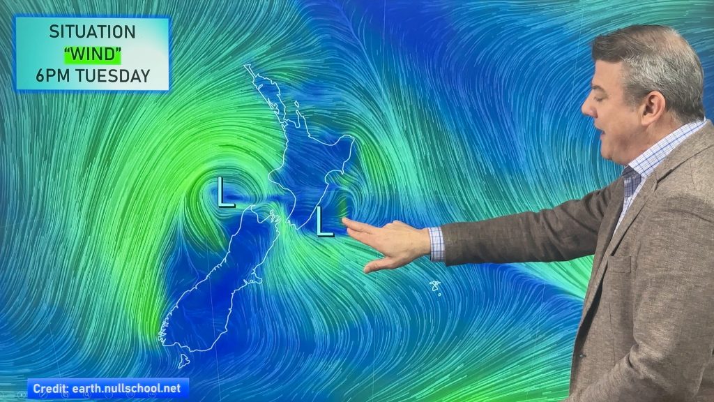
Wet weather along with a windier, cooler, change is moving across NZ today and tonight, dropping the muggy humidity around the North Island and bring a drop in temperatures nationwide as we go into Wednesday.
By Thursday high pressure expands over the country, lingering into the weekend for most regions – we explain which places may still have a few showers and temperature changes, with southern parts of the South Island most exposed to some weak cold fronts.
Considering how unsettled NZ’s weather has been over the past two months, and despite the low pressure zone crossing the country tonight, we do see a generally more settled weather pattern over the next week or two.
Comments
Latest Video

Rain & showers this weekend, colder change next week
Some places will warm up over the next day or so as a nor’wester out of Australia moves across NZ,…
Related Articles
Rain & showers this weekend, colder change next week
Some places will warm up over the next day or so as a nor’wester out of Australia moves across NZ,…

Temperature changes for some regions ahead of heavy West Coast rain
A nor-wester is about to kick in and it’s coming from out of Australia, boosting temperatures in some regions going…

NZ 7 day forecast: Showers, temp changes and heavy West Coast rain
NZ has a fairly messy forecast over the next 7 days, but the main feature will be heavy rain on…


Craig wells on 3/02/2026 6:07am
Big 2 day speedway event in Palmerston north this weekend how does wether look
WW Forecast Team on 3/02/2026 5:48pm
Hi Craig, check out the weather graphs we have at RuralWeather.co.nz – it’s showing mainly dry weather, might be a couple of showers, and westerly winds: https://www.ruralweather.co.nz/forecasts/Palmerston%20North,%20Manawat%C5%AB-Whanganui
Cheers,
– WW
GPF on 3/02/2026 12:35am
High pressure extending over Auckland Saturday/Sunday. Will it come with strong winds (looking at boating on Waitematā)?
WW Forecast Team on 3/02/2026 2:53am
Hi there,looks a little brisk if you look at our wind graphs here: https://www.ruralweather.co.nz/forecasts/Auckland
And try our marine maps here: https://www.weatherwatch.co.nz/maps-radars/marine/ripple
If you can find a sheltered spot you may be ok, but it’s a little bit like today
Good luck!
– WW