Cyclone Cody may directly impact NZ – Here’s the current best thinking (+Maps & Animation)
11/01/2022 9:17pm

> From the WeatherWatch archives
Developing — Tropical Cyclone Cody intensified overnight to a Category 2 storm, this despite it tracking southwards away from the equator. La Nina is helping boost sea surface temperatures in our part of the world and the marine heatwave occurring in parts of the North Island may help keep Cody a powerful storm as it tracks past later this weekend or early next week.
This map – from the Moana Project – shows how much warmer than average it currently is around the North Island. Warm waters like this fuel storms.

While Cody will technically lose the “tropical cyclone” part to the name by the time it reaches NZ, the storm itself may still be producing similar gales and rain. The ex-cyclone is expected to then impact the North Island with a chance of a direct hit/landfall in the upper eastern North Island (East Cape or Bay of Plenty, for example).
High pressure further south and to the west and east will also play a significant role at guiding this storm… so yes, there remains uncertainty about precise tracking into the NZ area. It’s not yet locked in – but the data is becoming more aligned.
WILL CODY MISS NZ?
There is a chance this may happen – as with any cyclone tracking north to south our narrow country also lies north to south…this means a slight movement further east or west for Cody will have significant impacts to our forecasts. But modelling suggests there is a moderate to high chance of NZ’s weather – and certainly our beaches – being impacted by Cody for a time this weekend into early to mid next week, mainly the North Island.

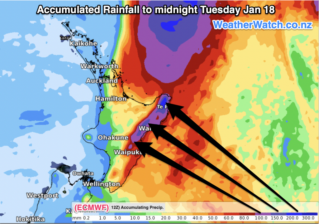
WeatherWatch.co.nz says that those in the upper North Island and the eastern side need to be prepared for wind and rain. Damaging gales may brush northern and eastern areas while rain looks more likely in eastern areas with over 200mm already being forecast in some models. This is enough to cause slips, flooding and road closures. See the maps below for the latest estimates.
WHO’S THE BOSS?
Currently it’s the Fiji MetService with responsibility for official Government forecast updates on Cody but by Thursday it will be handed to MetService NZ for official updates here (not Government Agency NIWA, which is already using this storm to promote their commercial services against MetService via the media – no other country has a Government Agency do this against their official Government forecaster during storms. It’s also worth noting NIWA is so aggressively commercial they won’t share their tax funded computer tracking with the private weather sector).
Having Niwa compete with MetService (Govt agency vs Govt agency) only confuses the public with two ‘Government sources’ providing different forecasts. MetService has WeatherWatch.co.nz’s full support.

MetService will today produce their own tracking map for Cody which will help show which parts of NZ are most at risk.
WeatherWatch.co.nz says it’s too early to yet lock in precise tracking, so the “cone of uncertainty’ – which shows the wiggle room where Cody may track – is the current best way to track areas most exposed to stormy weather.
With the storm at sea for a number of days ahead there may not be a lot of new information across each day – but we’ll now provide DAILY updates here at WeatherWatch.co.nz and RuralWeather.co.nz.
In the mean time, your hyper-local forecasts here at WeatherWatch/RuralWeather use IBM’s supercomputer ‘Watson’ which crunches ALL reliable modelling to produce the most likely forecast in your area. (In other words, if the maps and models confuse you then our hyper-local forecasts do all the work and display it in one easy forecast, no matter which part of NZ you’re looking at).
Regional MetService Warnings aren’t likely to be issued until the weekend.


Please note, this map is produced with thanks to the US Government.
Comments
Before you add a new comment, take note this story was published on 11 Jan 2022.
Latest Video

VIDEO: ClimateWatch: July is the month of BIG lows, BIG highs
This month around New Zealand, Australia and the region we see big highs and big lows – bringing decent stretches…
Related Articles
VIDEO: ClimateWatch: July is the month of BIG lows, BIG highs
This month around New Zealand, Australia and the region we see big highs and big lows – bringing decent stretches…

VIDEO (NZ): Large low looms – who gets rain/wind & who does not
Another large low will bring severe weather to parts of both main islands of NZ this week, followed by a…

VIDEO: Another big low late week brings severe weather risks to NZ
Severe weather is back in the forecast later this week after we kick off July with high pressure at the…


Add new comment
Marty on 12/01/2022 11:32pm
Niwa have an agenda to push. Climate Change.
Reply
John on 13/01/2022 6:52am
What do you mean “an agenda to push climate change?” MIWA push no agenda, they are trying to tell you something, but for some reason, you’re not listening. None so dumb who will not hear.
Reply
Phil Smith on 12/01/2022 8:14pm
Hi Phil & team, question , wont the high in the Tasman push ex tropical storm away from us like it always does or will it die and allow storm to come in
Reply
WW Forecast Team on 12/01/2022 10:56pm
The high seems to slip out to our east during the course of this weekend, looks to allow the TC to drop south on the back end of it where the high isn’t blocking as much. Things could change still but as we get closer confidence increases this will affect the North Island in some way for sure. We’ll have another story on TC Cody coming out soon so keep an eye out for that. You can always follow our maps here to see what may happen:
https://www.weatherwatch.co.nz/maps-radars/rain/rain-forecast
WW
Reply
Mark Longstaff on 11/01/2022 9:54pm
Once again you have provided a well considered, crafted and presented product.
Hearing you re Govt agencies fighting it out and will raise with Act and National MP
Reply
WW Forecast Team on 12/01/2022 1:45am
Hi Mark, thanks for your support. We’ve had 10+ years of MPs saying they support us (from Labour to National) and nothing ever changes. The more people who complain about the system being broken the better. Kia Kaha!
– WW
Reply