Your web browser (Internet Explorer) is out of date. Some things will not look right and things might not work properly. Please download an up-to-date and free browser from here.

ClimateWatch: Summer outlook for NZ as La Nina also arrives (+15 Maps, +Video)

Originally published Dec 1 — We take a close look at the weather and climate trends for NZ across December, January and February now that La Nina is with us.

La Nina means north of NZ (in the tropics) there is an increased risk of low pressure zones and rainmakers. La Nina also means sea surface temperatures are above normal, not only north of NZ but also around NZ itself, with the North Island in particular experiencing a marine heatwave. Higher sea temperatures may also increase the chances of sharks this summer in some coastal areas.

This summer is definitely leaning warmer than normal, +1.3C above normal (at the higher end of the scale) in the lower South Island and +0.6C above normal (at the lower end of the scale) for the north eastern corner of the North Island. Get used to warm nights in the north and east too – the warmer sea surface temperatures (along with extra cloud cover) will help regulate places like Auckland and Wellington, bringing mild nights this summer.

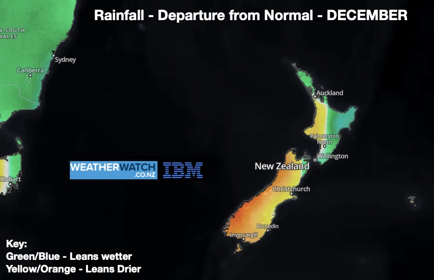
As for rain – yes we do see the classic La Nina set up with added rainfall chances in northern and northeastern regions, however the Southern Ocean (the normal Roaring Forties belt of weather) remains active and will likely dominate NZ’s weather, despite La Nina influencing us too. This means more variety in our weather pattern overall and so localised dry areas may well still take over, but extra humidity increases the chance of those hit and miss afternoon downpours.

The North Island may have quite a few showers this summer. Often in a La Nina summer the days can start off drizzly/light showers in eastern coastal areas, sea breezes then push that moisture inland where daytime heating gathers it all up into large towering afternoon cloud build ups. These downpours can deliver a lot of rain – but it’s quite localised. Long-range rainfall maps often show these downpours as one big ‘blob’ of rain, when in theory they are many downpours/showers within that region over the coming weeks (so not everyone gets the rain they may hope for). You may notice this is demonstrated in the 2 week rainfall maps.


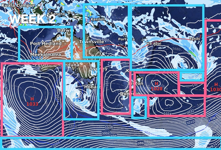
DECEMBER – Tracking the Highs and Lows:

Week 1 kicks off with a powerful belt of high pressure in the NZ area and showers in the North Island. Rain also moves into the West Coast as this high shifts eastwards. The N to NE airflows are classic La Nina, but the increased rain on the West Coast is a reminder that La Nina doesn’t dominate our weather 24/7.
La Nina weather patterns come to life more in the second week of December with low pressure zones stretching from Western Australia to New Caledonia to Rarotonga. However, powerful high pressure zones in the Roaring Forties will continue to cross NZ and influence us – bringing plenty of dry weather but also inland downpours.
Week 3 shows still powerful high pressure zones are coming through the NZ area from the Southern Ocean, but the tropics is still mostly dominated by low pressure thanks to La Nina.


UPCOMING EXPECTED RAINFALL:

As far as rainfall is concerned, the first week of December doesn’t look like La Nina, with heavy rain returning to the West Coast while northern NZ leans drier than normal.
Big Picture: The bulk of NZ’s rain in the first half of December will be actually be coming to us from the west. It is connected to the La Nina rain being driven into Eastern Australia, but because it’s coming into NZ from the west it reverses what we typically see in a La Nina set up. This is also what WeatherWatch.co.nz has been saying for several weeks now – that our location on earth (half way to Antarctica from the Equator) means we get both La Nina weather patterns but also our usual prevailing west to east weather pattern too.
Close up shows NZ’s upcoming rainfall totals over the next two weeks The West Coast has over 300mm coming while coastal parts of Canterbury may have only 15 to 30mm. The North Island shows signs of afternoon downpours developing (La Nina increases heat and humidity which can mean coastal morning cloud/drizzle and afternoon sun/with cloud build ups and heavy downpours inland).
For the most part much of NZ actually leans drier than average for December – but rainmakers are expected to brush the North Island bringing either normal December rainfall, or perhaps even a little more for some spots. Please remember – despite the long range data showing trends of increased rainfall, our localised Mountains and Ranges heavily impact totals and create rain shadows.
Long Range for Summer and it shows rainfall may creep up as we head into January and February (likely to see an increased chance of northern and Tasman Sea rainmakers). The South Island still mostly leans drier than normal. Not everyone in green shading will be wetter than average this summer but the green zones show which areas do have an increased chance of rainmakers in the weeks ahead.


UPCOMING EXPECTED TEMPERATURES:

There’s no doubt about it, the next three months lean warmer than average nationwide – following the same trend we’ve seen across 2021. The lower half of the South Island will be warmest (compared to usual), especially inland areas which will climb well over 1 degree above normal over the coming months.


LA NINA / MARINE CONDITIONS:

La Nina is officially here says scientists we trust at the Bureau of Meteorology (BoM).
Yes – La Nina is here.
Yes – La Nina is likely to linger all summer
No – this is not a powerful La Nina
No – this is not expected to be a long lasting La Nina, fading out by about March/April
(Graphs by BoM)
Sea Surface Temperatures – Anomaly Map. This shows La Nina has formed… this is when the easterlies over the equatorial Pacific Ocean blow warm surface water westwards towards our side of the globe (and makes it cooler than usual in the eastern Pacific Ocean) (Data: US Government).
Current sea surface temperatures – already over 20C in the sea in the upper North Island. Great for swimming (just keep an eye out for possible sharks this summer, there may be more around NZ due to the extra marine heat). A big thanks to the Moana Project for these maps.
A marine heatwave is again underway in some parts of NZ which are 2 or 3 degrees warmer than normal. A big thanks to the Moana Project for these maps. https://www.moanaproject.org/marine-heatwave-forecast
NZ is halfway between the Equator and Antarctica. This means we don’t have La Nina weather conditions 24/7, we still get influenced (significantly) by the Roaring Forties belt of weather that tracks from west to east and – from time to time – will shove La Nina weather patterns aside for NZ.

Comments

Related Articles