Big doesn’t always mean bad for everyone as Southern Ocean storm forms (+3 Maps)
1/12/2019 6:51pm

> From the WeatherWatch archives
UPDATED 7:51am Monday — A huge area of low pressure is forming in the Southern Ocean creating a large storm which will span thousands of kilometres in diameter and brush New Zealand and south eastern Australia. It will affect our weather for about seven full days.
The storm itself won’t directly cross NZ, but it’s so large in size it can’t help but swipe us.
It means pockets of severe weather, potentially in both islands for a time, but while this is definitely one of the larger storms we’ve seen this year it also doesn’t equal an especially rough time for many parts of New Zealand. In fact for some areas it may enhance the sunny and hot weather you’ve already been having lately.
Big doesn’t always mean bad as these large weather systems tend to have very large areas of calm or what most of us would consider “normal” weather. Of course, being in a ship in the Southern Ocean next week would be a terrifying ordeal with gigantic seas and hurricane force winds. But for New Zealand and Tasmania – we’re on the edges of it and because it’s so large we will have plenty of non-severe weather in the mix too.
Most impacted by rain will be the West Coast with significant totals there which could leads to slips, flooding and road closures. Some snow on the ranges too. Winds will be strongest in the east, but especially around the mountains and Cook Strait next week.
The low pressure will remain hugging NZ just to our south until Monday of next week and basically means a westerly flow will kick in with rain on the West Coast, winds through central and eastern areas and remaining warmer than normal in the east and north. This set up doesn’t mean severe weather for all – so keep up to date with MetService for more details on where the official weather warnings are.
WHICH REGIONS ARE MOST IMPACTED NEXT WEEK:
- The West Coast is most affected. Rainfall totals are excessive and over the next 3 days alone nearly half a metre of rain is possible. Around Franz Josef the totals could be 400 to 500mm with around 200mm as far north as Westport.
- On Monday night and across Tuesday a surge of gale force NW winds moves up the South Island, Cook Strait and Lower North Island. This typically mostly affects the eastern side of the South Island and Wellington/Southern Wairarapa. Wind warnings may be possible for a time.
- Over Wednesday/Thursday gusty NW winds blow for some regions (the usual wind tunnels like Wellington/Cook Strait and through the Southern Alps) but peaks aren’t as high as Tuesday – gales are still posible.
- On Thursday a pool of slightly cooler air brushes the West Coast, Southland and coastal Otago – short lived though.
- Wellington has a bit of a windy week ahead but really only Tuesday has the severe gale risk, although Wednesday and Thursday look to have gales at times.
REGIONS LEAST IMPACTED:
- Northern NZ and the eastern North Island north of Masterton
- Hawke’s Bay has no rain forecast in the next 10 days (other than showers possible over the inland ranges). Main centres like Napier and Hastings are dry and hot with highs in the mid to late 20s, maybe early 30s. Similar with Gisborne.
- The top of the North Island has a little bit of windier weather and some brief rain or showers next week – but it’s nothing that would hint to a huge storm in the Southern Ocean.
WEDNESDAY AIR PRESSURE AND RAIN MAP: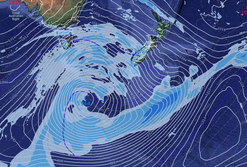
3 DAY RAINFALL TOTALS UNTIL 7AM THURSDAY:

– WeatherWatch.co.nz
Comments
Latest Video

Polar airflows set to bring cold weekend to NZ
Nor-west winds will be building over parts of NZ going into Thursday with rain on the West Coast becoming heavy…
Related Articles

NZ: Cold & windy, then calm & frosty
Downpours, some squally with the chance of thunderstorms and even small tornadoes are possible for parts of NZ over Friday…

WeatherWatch App launches real-time local lightning tracker
A bolt out of the blue! WeatherWatch has launched a live, real-time lightning tracker, enabling Kiwis to gain access to data provided by the…

Wind, rain, showers & a noticeable temperature drop for all
It will be a colder weekend right across NZ as a sub-Antarctic southerly blows through, bringing frosts, snow flurries and…


Chrissy on 1/12/2019 6:30pm
Thanks Phil. As usual a really easy to understand, well explained forcast. Love your new site. Well done. Congratulations to you and your team. Cheers. Chrissy