Latest on severe weather risks leading up to Sun/Mon’s east coast storm
12/02/2026 11:10pm
Severe weather risks start today, even though a storm isn’t forecast until Monday as low pressure replaces high pressure over New Zealand, bringing instability. This instability will lead to hit and miss heavy downpours across the North Island in particular today, fuelled by a tropical northerly.
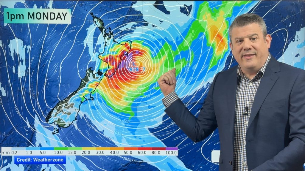
On Saturday and Sunday a subtropical low will deepen off East Cape and that will produce a cooler southerly, but as this low powers up it will see both rain and wind increasing around the eastern side of the country.
Precise tracking of this new stormy low early next week still can’t be locked in – but we show you various rainmaps to make sense of it all.
Due to the nature of this low, and because of recent landslides and flooding in eastern parts of the North Island, we will have special weekend video updates on both Saturday and Sunday.
The South Island’s is also exposed to some heavy rain and strong winds, depending on the tracking of this east coast storm next week.
Keep up to date with MetService warnings and watches.
- WeatherWatch.co.nz / RuralWeather.co.nz / Mobile App
Comments
Latest Video

Frosts, late week rain & another cold weekend coming
High pressure will cross NZ over the next few days meaning more cold nights/mornings with frosts, but a nor’wester will…
Related Articles
Frosts, late week rain & another cold weekend coming
High pressure will cross NZ over the next few days meaning more cold nights/mornings with frosts, but a nor’wester will…

NZ: Cold & windy, then calm & frosty
Downpours, some squally with the chance of thunderstorms and even small tornadoes are possible for parts of NZ over Friday…

WeatherWatch App launches real-time local lightning tracker
A bolt out of the blue! WeatherWatch has launched a live, real-time lightning tracker, enabling Kiwis to gain access to data provided by the…


MikeL on 13/02/2026 12:24am
While not specifically cyclonic the picture presented is remarkably similar to the Feb 2023 weather patterns that evolved into Cyclone Gabrielle
Greg (surfer) on 13/02/2026 3:14am
MikeL, ‘Gabrielle’ had been downgraded to ex-TC Gabrielle 48 hours (2 days) before arriving on our shores: it was ‘cyclonic’ but it was NOT a tropical cyclone.
And yes they both shall be known as The Valentine’s Day Storm(s), typical weather for this time of year. Be safe & enjoy.