April ClimateWatch: La Nina ends, now here’s what NZ can expect (+11 Maps & Video)
31/03/2021 9:52pm
> From the WeatherWatch archives
La Nina has come to an end according to scientists at the Bureau of Meteorology. As WeatherWatch.co.nz and RuralWeather.co.nz said back in spring of 2020, this fairly short lived La Nina wasn’t going to be the silver bullet for the drought/dry parts of NZ and instead rather a silver lining.
While La Nina did bring some intense downpours in December, early January and again in recent weeks – the rain relief has been very “hit and miss”. Even within some close knit rural communities or within one suburb of a city some had huge downpours while others nearby got next to nothing.
The reason La Nina wasn’t going to necessarily bring a major wet summer to New Zealand was due to the fact it wasn’t overly strong or long lived and that the high pressure belts over NZ have been above normal for the past two years (and counting).
So with La Nina gone, it’s now this continuation of above normal high pressure that will continue to dominate our country. But just because La Nina is over doesn’t mean the tropics north of NZ have gone cold and quiet. A low in the second week of April may produce a rainmaker for northern or western NZ (not locked in but possible, as you will see in our ClimateWatch April video update).
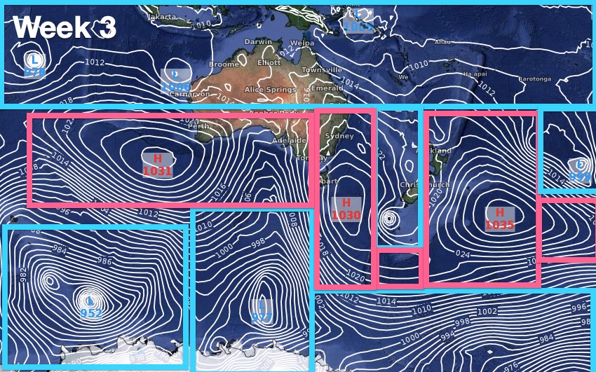
HOW THE HIGHS AND LOWS ARE SHAPING UP IN APRIL:


EXPECTED APRIL RAINFALL:
The NZ areas kicks off the first half of April with an “Air Pressure Sandwich”. This means we have a belt of low pressure across the tropics, a belt of high pressure in a line from the Indian Ocean to just south of Aussie and into the NZ area, and then south in the Southern Ocean lies another belt of low pressure. All things considered neither of these low pressure belts (in the tropics or Southern Ocean) look overly stormy at this stage.
The increased high pressure in the NZ area for two years (still yet explained by scientists in NZ) carries on into April and this will mean inland and eastern areas lean drier than average.
A low in the Tasman Sea in April’s second week has the potential to deliver heavy rain to the upper North Island and/or the West Coast – but again it will be the dominating high pressure belt that will be the decider on if this low makes it to NZ with much needed rain.

(Map with thanks to the US Government…)
Red = Drier than usual. White = Normal rainfall for this time of year. Blue = Wetter than usual.
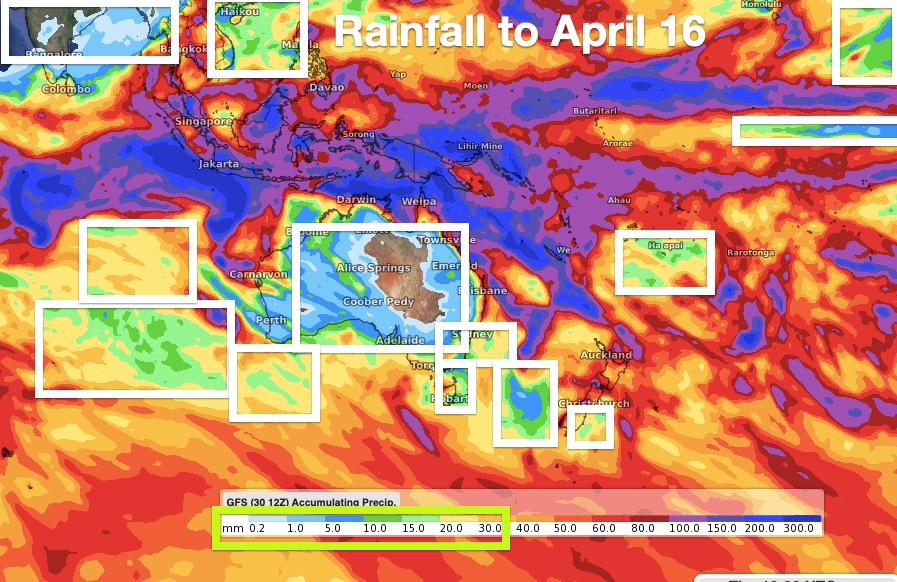
Areas in white boxes indicate zones with little to no rain (highlighted in the key by a green box showing just 0.2 and 30mm over the next 16 days ahead). These areas are dry mostly due to dominating high pressure. The heaviest rain lies in the tropics and slides into parts of the Tasman Sea next weekend as a low tries to reach NZ. Rainfall in these dark blue/purple areas is at the far end of the key: 100 to 300mm.

This is suggesting that southern and eastern parts of the North Island will continue to lean drier than average. Meanwhile western and northern NZ may lean wetter than usual BUT it must be noted this will only occur if that Tasman Sea low from the tropics makes it to NZ. If not, we expect these areas to also lean drier than normal again.
Powered by IBM

Drier than usual across Southland, Otago, Nelson and Marlborough – and most likely drier than average through much of Canterbury also. The map above does indicate a slight lean into the green for Canterbury and may include “spill over rain” from the West Coast which can often fail to extend very far east of the ranges. So just an extra caution there. The populated parts of the West Coast continue to be about right or even a little wetter than average.
Powered by IBM
CURRENT SOIL MAPS:

Powered by IBM

Powered by IBM

Powered by IBM
FORECAST AIR TEMPERATURE TREND FOR THE MONTH OF APRIL:
Powered by IBM.
*WeatherWatch.co.nz / IBM / RuralWeather.co.nz
Comments
Latest Video

Colder nights/mornings, polar change coming Sun/Mon
The nights and mornings ahead will be colder in a number of regions – but an even colder change is…
Related Articles
Colder nights/mornings, polar change coming Sun/Mon
The nights and mornings ahead will be colder in a number of regions – but an even colder change is…

Frosts, clearer skies coming – severe weather possible this weekend
High pressure lies south of NZ today and that placement encourages a colder south-east wind into the North Island bringing…

NZ: 8 Day outlook as gales & rain ease, high pressure builds
Damaging wind gusts and heavy rain will continue to affect some parts of the North Island and brushing Marlborough today…


Anthony on 1/04/2021 9:28am
This is great content, thanks 😊
WW Forecast Team on 1/04/2021 8:56pm
Thanks Anthony! Much appreciated
– WW