What does this big low mean for New Zealand? We explain the rain (+4 Maps)
10/05/2018 10:38pm

> From the WeatherWatch archives
A storm in the Tasman Sea is set to bring a blast of severe weather to the south eastern side of Australia but what does it mean for New Zealand specifically?
For the most part this very large low will be Australia’s problem over the next few days however between this large low and the outgoing high we have an area of convergence (air flows that meet) and this occurs over the upper North Island. On top of that a smaller ‘spin off’ low is approaching the South Island today over the Tasman Sea with a burst of wind and rain.
Generally speaking this weekend the nor’west flow coming out of the storm near Australia plus the sub-tropical north to north east flow coming from the departing high will be meeting over the North Island (or near it – some of the heaviest falls may be just offshore). This means rain will be sub-tropical in nature (so a mix of drizzly spells but also very heavy falls). Due to the slow moving nature of everything these rain bands could cause localised flooding. It will be warmer than average too.
The actual storm itself near Australia won’t even reach New Zealand until the end of Tuesday and likely cross the country on Wednesday – so the rain over the next few days is a bit of a precursor. New Zealand lies halfway between the centre of this low near Aussie and the large high to our east.
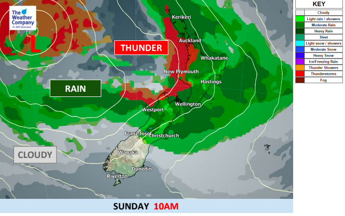
NEW ZEALAND HIGHLIGHTS
- A small but potent low will this afternoon cross the lower South Island bringing a burst of heavy rain (which will spillover into Otago and Southland for a time) and some brief gales.
- Rain in many parts of northern and western New Zealand next three to five days with heaviest rain in the upper North Island at this stage.
- Warm and humid air will also flow ahead of the low pressure system producing *isolated* thunderstorms.
- Gale winds will also be possible in coastal areas, mainly in the Cook Strait area.
- The small low approaching the South Island today will clear off tonight and a small high will in fact return and cover over the South Island tomorrow.
- Sunshine will return in some areas of the South Island, but the trough will stay in the North Island bringing rain to the northern half on Saturday and further down the eastern side on Sunday. Stll plenty of dry areas.
- On Sunday rain may be heavier, especially in the upper North Island but some of the worst rain may be offshore – so one to monitor.


– WeatherWatch.co.nz – Proud to be an official IBM/TWC business partner
Latest Video

Cold weekend, frosts return with high pressure, then a low late next week
The subantarctic airflow spreads over NZ today/tonight and into Saturday, dropping temperatures nationwide. Snow flurries are possible today to lower…
Related Articles
Cold weekend, frosts return with high pressure, then a low late next week
The subantarctic airflow spreads over NZ today/tonight and into Saturday, dropping temperatures nationwide. Snow flurries are possible today to lower…

Wintry burst of weather: Snow, squally showers then sunshine & frosts
A polar change (another one!) arrives on Friday for the South Island and goes nationwide on Saturday, leaving NZ under…

Antarctic southerly for parts of NZ Fri & Sat
For the first time this year a southerly from off Antarctica is heading towards the South Island, followed by more…

