Weekend thunder, a West Coast deluge and a brief cool change Monday (+8 Maps)
6/12/2019 1:56am

> From the WeatherWatch archives
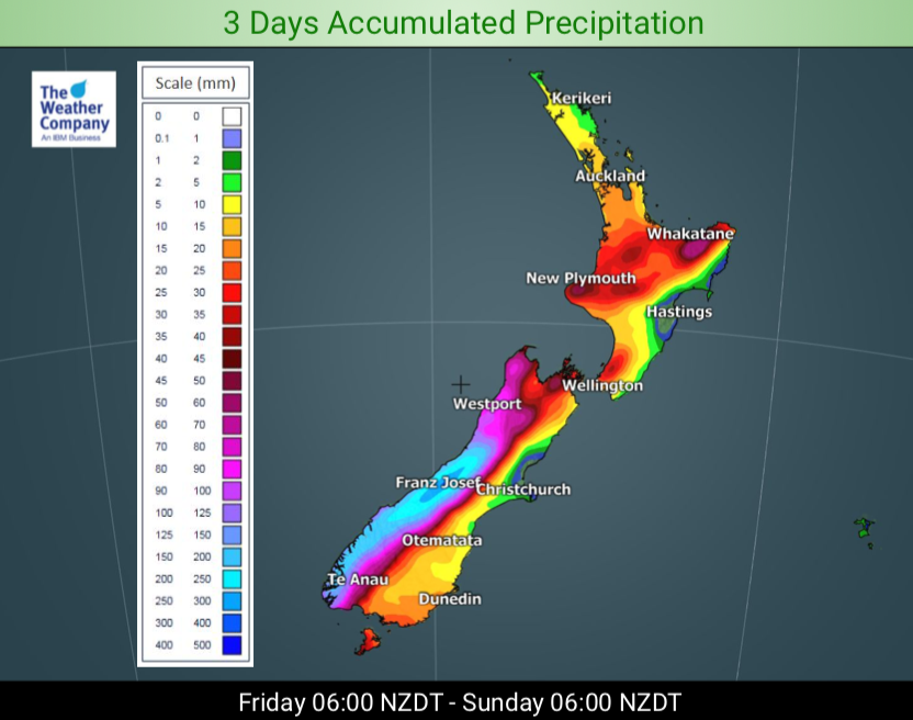
Over 200mm of rain is coming for parts of the West Coast in just a day, double that over the weekend. Meanwhile northern NZ may have thunderstorms as more sub-tropical warmth spreads down over the island ahead of a cold front on Sunday.
WeatherWatch.co.nz says temperatures this weekend will, for the most part, continue to be warmer than normal in may regions.
The storm in the Southern Ocean is now weakening and moving in towards the country. The placement of this large storm south of NZ and Australia has helped fuel the the wind, hot and dry weather over Australia that sparked a flurry of big fires on Thursday and sent thick smoke clouds over Sydney and across New Zealand. This continues for Friday but this weekend the air patterns alter as this (now much weaker) Southern Ocean low moves into the South Island.
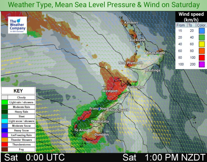
This means winds will pick up nationwide with gusty winds on Sunday in some areas. The low will cross the South Island on Sunday.
Heavy rain moves into the North Island on Monday with some downpours making it into very dry northern and eastern regions.
The thunderstorm risk on Sunday is widespread – but as we often see in NZ thunderstorms are a bit hit and miss. So you may have thunderstorms in your local forecast but they may form nearby and drift away from you – or they form directly above. Keep an eye on MetService’s thunderstorm outlook combined with WeatherWatch.co.nz’s news and infographic updates across this weekend for more details.
Sunday’s action also ushers in a very brief cool change. A south to south west airflow moves in nationwide dropping temperatures by a few to several degrees. But this action only simply resets most regions back to “normal” daytime highs. (*normal based on decades of averages). There will be a few places colder than average on Monday (see departure from normal temperature maps below) but it’s short lived with warmer winds returning by Tuesday in the South Island at least. Overnight lows will be below normal for a couple nights too.
IMPACTS –
-
Thunderstorms with stray hail showers:
– Until Sunday late night over South Island partially. Until Monday evening over North Island widely. In some cases the risk may be widespread but thunderstorms hit and miss/isolated. -
Rain:
– Accumulated precipitation of 50 mm / 24h or more is widely expected over Southland & West Coast until Sunday morning, and especially 200 mm / 24h or more from Friday to Saturday morning.
– Accumulated precipitation of 300 mm / 72h or more is expected in mountainous areas of West Coast. -
Snow (high altitude areas of Southland & West Coast):
– In West Coast with altitudes above 1,500m, accumulated snow of 100 cm / 24h or more is partially expected until Monday morning. – Accumulated snow of 30 cm / 24 h or more is partially expected in Southland with altitudes above 1,000m until Monday morning. -
Wind: average wind speed of 60 km/h or more (gale force) is expected as follows
– Around Cook Strait, northwesterly strong winds are expected from Sunday morning evening (average wind speed of up to 80 km/h). – Until Monday morning over coastal Southland (westerly winds).
– At least until Sunday noon in high altitude areas of South Island. -
Wave (west side of coastal South Island):
– Significant Wave Height (SWH) of 4 m or more is widely expected until Monday morning.


– WeatherWatch.co.nz
Latest Video

Colder nights/mornings, polar change coming Sun/Mon
The nights and mornings ahead will be colder in a number of regions – but an even colder change is…
Related Articles
Colder nights/mornings, polar change coming Sun/Mon
The nights and mornings ahead will be colder in a number of regions – but an even colder change is…

Frosts, clearer skies coming – severe weather possible this weekend
High pressure lies south of NZ today and that placement encourages a colder south-east wind into the North Island bringing…

NZ: 8 Day outlook as gales & rain ease, high pressure builds
Damaging wind gusts and heavy rain will continue to affect some parts of the North Island and brushing Marlborough today…

