Weather ‘bomb’ possible Sunday/Monday in Southern Ocean – Severe weather risks for NZ
21/09/2020 10:53pm
> From the WeatherWatch archives
A nasty low pressure system is expected to rapidly develop this Sunday and Monday with modelling today suggesting it may reach weather bomb criteria.
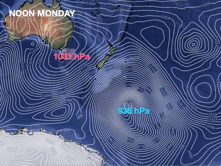
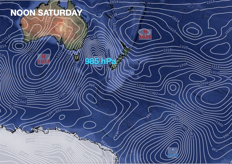
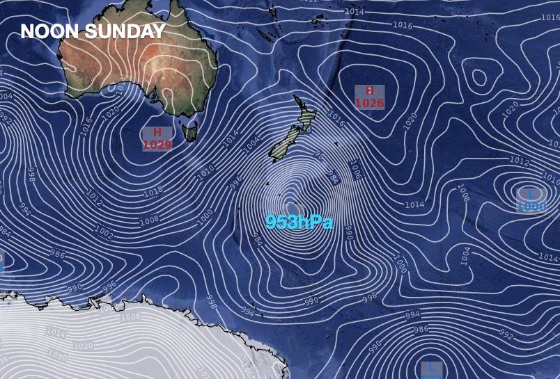
A weather bomb (technically known as bombogenesis) is when a depression drops 1 hectopascal (hPa) an hour for 24 hours. At Noon Saturday the low is forecast by GFS modelling to be 985 hPa, by Noon Sunday 950 hPa (a drop of 35 hPa!) and by noon Monday 936 hPa. This would make this storm deeper than the hurricanes that have recently hit the United States. (Hurricane Laura recently peaked at 937 hPa).
ECMWF modelling (from Europe) also paints a similar picture from 984 hPa on Noon Saturday to 962 hPa on Noon Sunday (2 hPa shy of reaching ‘bomb’ criteria), then down to 936 hPa on Monday (a drop of 26 hPa in 24 hours).
Of course these are just what the computer models are forecasting and over the next few days there will likely be changes in these numbers and precise location/tracking of the expected low, but the general picture is that a low in the South Tasman Sea area will track south east (south of NZ) and over the Southern Ocean – at which point it rapidly develops into a very serious storm (on global levels). However it will be in the Southern Ocean and not tracking directly over NZ.
There will also be a huge air pressure gradient between this storm and the high building over south eastern Australia. In fact, there may be an almost 100hPa range (which is stunning) between the centre of the high and centre of this storm – meaning plenty more spring winds are yet to come.
This next high may be what helps push the storm away from NZ faster though.
NZ SEVERE WEATHER RISKS:
Regardless of if this low technically reaches bombogenesis status remains to be seen, but the likelihood of severe spring gales, and a wintry change, are quite possible around parts of NZ this Sunday and Monday, with cooler weather lingering in the south until mid next week.
Over the next few days we’ll continue to monitor this closely but nor’west gales, heavy West Coast rain and some snow and low temperatures in the south are all possible. It’s still early to lock in though – so this remains One to Watch.
Don’t forget our www.RuralWeather.co.nz website is already crunching all the models and producing a forecast for your specific location. Here you can check hourly barometric pressure at your property for the next 10 days – along with wind, rain and temperatures, cloud cover and more. It’s free to access for the rest of 2020.


www.RuralWeather.co.nz for more data
- WeatherWatch.co.nz
Comments
Latest Video

Polar airflows set to bring cold weekend to NZ
Nor-west winds will be building over parts of NZ going into Thursday with rain on the West Coast becoming heavy…
Related Articles

NZ: Cold & windy, then calm & frosty
Downpours, some squally with the chance of thunderstorms and even small tornadoes are possible for parts of NZ over Friday…

WeatherWatch App launches real-time local lightning tracker
A bolt out of the blue! WeatherWatch has launched a live, real-time lightning tracker, enabling Kiwis to gain access to data provided by the…

Wind, rain, showers & a noticeable temperature drop for all
It will be a colder weekend right across NZ as a sub-Antarctic southerly blows through, bringing frosts, snow flurries and…


Kim on 22/09/2020 3:28am
wouldn’t this affect the Chatham Islands? – looking at the maps above.
WW Forecast Team on 22/09/2020 7:06pm
Hi Kim, yes it may well give them a pretty big blast. We’ll take a closer look in our weather video today. The Chatham Islands are no strangers to big storms, so hopefully it will be ‘business as usual’ there.
Cheers
Phil D