Tropical low, then windy, cooler, weather dominates until early next week
20/01/2026 11:52pm
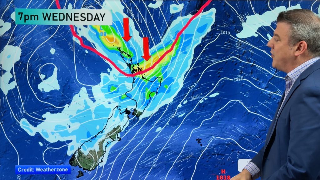
We have full details on the wind, rain and tropical humidity descending into New Zealand today, tonight and Thursday – then explain how the low will park itself between the South Island and the Chatham Islands this weekend and into early next week, creating a colder/cooler southerly change (and perhaps more west to south-west for the North Island).
Heaviest rain today and Thursday looks to be leaning east in the upper North Island, for Northland, Auckland, Coromandel Peninsula, Bay of Plenty, East Cape, Gisborne and northern Hawke’s Bay, but rain may also spread into Canterbury and other regions of the South Island.
Tropical humidity will also be a significant feature of this low later today, tonight/overnight and Thursday morning – especially the top half of the North Island with some very muggy weather coming in, before a more refreshing westerly arrives on Thursday PM.
The windy weather sticks around for some regions for a number of days, with showers around the South Island and especially the western side of the North Island.
We break it all down for you.
With such a large low, forecasts may change – as is the nature of big low pressure zones interacting with our mountains and ranges. Keep up to date with our hourly forecasts in our free WeatherWatch App or RuralWeather.co.nz and of course the MetService severe weather warnings and watches.
Comments
Latest Video

Antarctic southerly for parts of NZ Fri & Sat
For the first time this year a southerly from off Antarctica is heading towards the South Island, followed by more…
Related Articles
Antarctic southerly for parts of NZ Fri & Sat
For the first time this year a southerly from off Antarctica is heading towards the South Island, followed by more…

Meteors – Your Eyewitness Reports!
WeatherWatch.co.nz receives meteor reports from all over New Zealand and the globe, 24/7/365. **CASUAL COMMENTS**If you’ve seen something in the…

Snow, rain showers & cold polar southerlies set to return
Friday will be a wintry day across NZ as the next cold front arrives, bringing snow to lower levels of…


Chris on 21/01/2026 8:38am
If the wind is southerly, then surely there will be showers at most rather than continuous rain in Central Otago?
WW Forecast Team on 21/01/2026 9:30am
Hi Chris, not sure precisely what day you’re referring to but on Friday there is some low pressure forming over Otago/South Canterbury that could make some slow moving showers/areas of rain – not really being pushed in by southerlies… in fact those winds look light for Central Otago. Currently rainfall totals look around 15 – 20mm (Alex, Cromwell) due to that small area of low pressure expected over the region. But worth noting just to the south, in Northern Southland (like Gore), only expecting 7mm at this stage and north of Alex, like in Lauder, only 9mm. So it’s going to be localised and may still move around a bit (due to the instability due to that weak low pressure area over inland South Island – and the larger low driving it all offshore to the east). It may come in the form of either showers clustered together, or just some localised patchy rain/downpours. A little messy.
– WW