Tropical downpours come to New Zealand this week (+3 Maps)
14/02/2016 7:22pm

> From the WeatherWatch archives
We may not be directly hit by Winston but the tropical airflow behind this cyclone to our north, coupled with the remnants of ex-cyclone Tatiana to our north west, will be partially ‘sucked down’ over New Zealand this week by a sizeable low pressure system in the Southern Ocean.
This big low will pull down a narrow but significant stream of moisture rich tropical air – and will generate some very heavy downpours across Wednesday and Thursday. With a blocking high still out to our east it also means these rain bands could be slow moving – increasing the risks of possible flooding.
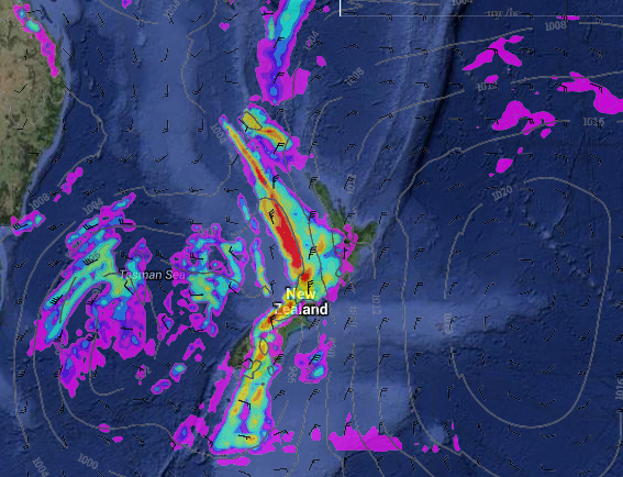 Wednesday evening’s rain map / MetOcean/Weathermap
Localised heavy, or torrential, downpours are likely this Wednesday, Thursday and Friday across various parts of both islands, in particular western, north western and northern facing regions.
The humid northerly quarter flow on Wednesday may be strong too, with low pressure in the Tasman Sea pushing close to a large high – the air pressure gradient becomes steep and the air moves faster.
Government funded forecaster MetService has high confidence of heavy rain this week prompting rain warnings and some confidence of severe gales – risks are in both islands and can be viewed via their severe weather outlook.
By Friday evening WeatherWatch.co.nz is forecasting a more refreshing westerly change, which should blow the last of the tropical downpours out east of the country and set up most of the country for a dry, settled, weekend as a high from the Tasman Sea moves in behind it all.
Cyclone Winston 
Winston remains a Severe Category 3 Cyclone this morning to the NNE of New Zealand. This storm will track NE towards Tonga – and poses a threat to Tonga, Fiji and surrounding islands in the coming days. The cyclone will be tracking into slightly more unfavourable conditions for it to grow and may even drop down another category – however it is not expected to weaken from a cyclone for several days.
Winston is not directly hitting New Zealand but swells of two to three metres will make beach conditions in the Far North and Northland more dangerous over the next few days. Swells from the N or NE are also expected to build around some parts of northern Auckland and eastern Coromandel Peninsula.
Later this week the low in the Tasman Sea will generate dangerous beach conditions and big seas right along New Zealand’s western coastline.

– WeatherWatch.co.nz
Latest Video

NZ: 8 Day outlook as gales & rain ease, high pressure builds
Damaging wind gusts and heavy rain will continue to affect some parts of the North Island and brushing Marlborough today…
Related Articles
NZ: 8 Day outlook as gales & rain ease, high pressure builds
Damaging wind gusts and heavy rain will continue to affect some parts of the North Island and brushing Marlborough today…

Pockets of hit & miss heavy rain, snow moves northwards
Low pressure continues to slowly move across the upper North Island and for some that will bring the sun out,…

Slow go for northern low & southern cold
For the next few days low pressure will crawl over the upper North Island, driving in rain as far south…

