Sunday’s Weather Headlines (x3): Tropical rainmaker, Humidity set to jump + tracking the rain
29/01/2022 6:33pm
> From the WeatherWatch archives
As we do daily now each morning, here are the top 3 main weather headlines for today, Sunday Jan 30.
TROPICAL LOW
An area of low pressure in the tropics won’t likely become a tropical cyclone — but it is a tropical rainmaker. The area of low pressure had the chances of becoming a cyclone however for a storm to form all the low pressure energy needs to be centred in one location. This low is stretched out with the energy spread too far, which limits how strong the winds get. High pressure in the NZ area is also limiting the chances of growth.
But as we said in our Friday weather video, this is more about the rainfall risks for NZ than it is about a storm coming our way.

RAINFALL CHANCES FOR NZ
The tropical low will bring heavy summer rain to a number of regions, but high pressure may just hold on to the North Island. With much of the North Island further east than the South Island, the tropical rainmaker may miss out bringing rain to very dry North Island regions. The line is very fine between drier than normal and wetter than normal as this tropical system drops southwards. Keep checking your local RuralWeather.co.nz or WeatherWatch forecast for more details on local rainfall chances where you are.
See rainfall accumulation map here.

HUMIDITY / OVERNIGHT TEMPS SET TO RISE
Even if the North Island misses out on heavy rain from the tropical low, it’s still likely to get more humid. Overnight lows are going to jump nationwide. Two good extremes to point out:
- Auckland: Has a week coming up of overnight lows in the 20s. Coupled with higher humidity the Humidex (or feels like) temperature will be around the mid 20s at midnight this week.
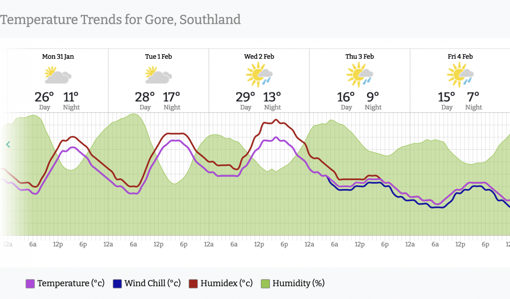
- Southland: Had a light frost on Friday morning as the overnight lows dropped closer to freezing. This week, the warmer northerly airflow will push the overnight low up to +17C by Tuesday night. (which, by the way, is warmer than Thursday’s daytime high once the tropical system has moved through!). Also worth noting the daytime highs will be around 30 degrees to kick off the start of February.
- www.RuralWeather.co.nz.

Weatherwatch.co.nz / RuralWeather.co.nz
Latest Video

Cold weekend, frosts return with high pressure, then a low late next week
The subantarctic airflow spreads over NZ today/tonight and into Saturday, dropping temperatures nationwide. Snow flurries are possible today to lower…
Related Articles
Cold weekend, frosts return with high pressure, then a low late next week
The subantarctic airflow spreads over NZ today/tonight and into Saturday, dropping temperatures nationwide. Snow flurries are possible today to lower…

Wintry burst of weather: Snow, squally showers then sunshine & frosts
A polar change (another one!) arrives on Friday for the South Island and goes nationwide on Saturday, leaving NZ under…

Antarctic southerly for parts of NZ Fri & Sat
For the first time this year a southerly from off Antarctica is heading towards the South Island, followed by more…

