Sunday’s national forecast: Severe weather chances across the country
26/09/2020 2:25pm

> From the WeatherWatch archives
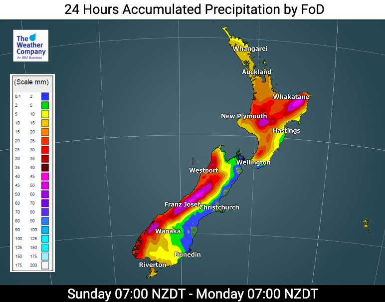
A storm is rapidly developing just south of New Zealand and while it’s moving away fairly fast it’s exploding in size, which means severe weather is likely across parts of New Zealand today – and the days ahead.
NEW: You can now find all MetService warnings via the WeatherWatch website: www.weatherwatch.co.nz/maps-radars/warnings
Heavy rain will fall along western New Zealand, strong to gale force winds will affect a number of parts of the country and a cold change is moving up the South Island. It gets even colder on Monday and colder still on Tuesday.
We’ll have more details later this morning on the blast.
Don’t forget www.RuralWeather.co.nz has you covered with hourly barometric pressure for 10 days out, wind speeds, direction, rainfall rates and snow icons if snow is likely in your local area.
www.RuralWeather.co.nz also has an automatic windchill calculator, just run the mouse along the graphs to see see hourly windchill for 10 days out. And yes, an app is coming out soon!
Stay safe and keep up to date with Government warnings from MetSevice and your WeatherWatch and RuralWeather.co.nz local forecasts and news/map updates in the days ahead.

www.WeatherWatch.co.nz / www.RuralWeather.co.nz
Latest Video

NZ: 8 Day outlook as gales & rain ease, high pressure builds
Damaging wind gusts and heavy rain will continue to affect some parts of the North Island and brushing Marlborough today…
Related Articles
NZ: 8 Day outlook as gales & rain ease, high pressure builds
Damaging wind gusts and heavy rain will continue to affect some parts of the North Island and brushing Marlborough today…

Pockets of hit & miss heavy rain, snow moves northwards
Low pressure continues to slowly move across the upper North Island and for some that will bring the sun out,…

Slow go for northern low & southern cold
For the next few days low pressure will crawl over the upper North Island, driving in rain as far south…

