Canterbury deluge continues into tonight as state of emergency now declared in Selwyn, following Ashburton & Timaru districts
30/05/2021 3:01am

> From the WeatherWatch archives
A large low is crossing NZ pushing rain into Canterbury, snow in the mountains and downpours for the north of NZ.
Generally speaking most parts of NZ actually don’t have severe weather – but exceptional rainfall totals are still expected in the eastern South Island (Canterbury). Check your local rainfall totals at WeatherWatch or RuralWeather – some in Canterbury are quite significant.

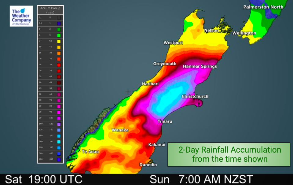
For example, Mount Somers has 160mm forecast for today only.
Darfield and Ashburton have just over 100mm forecast for today.
Christchurch has a much lower total of 34mm for today.
The most up to date information (like rainfall, temperatures and wind speeds/direction) can be found in your LOCAL forecast at WeatherWatch.co.nz or RuralWeather.co.nz – IBM crunches NZ and global data hourly.
Heavy rain is expected to continue in Canterbury with flooding and slips possible. Snow will be heavy in the mountains and ranges – over 1 metre possible before Tuesday.
A few isolated thunderstorms will affect the North Island with a few heavy falls.
We’ll have an even more detailed forecast again by mid morning as we crunch the very latest data and bring you more detailed maps to help explain the next 48 hours.
In the meantime, many maps and extra details can be found in our MAPS section.
Full list of current/active Watches and Warnings from MetService: https://www.weatherwatch.co.nz/maps-radars/warnings/metservice
Thunderstorm Risk today: https://www.weatherwatch.co.nz/maps-radars/lightning/thunderstorm-risk
MetService Thunderstorm Outlook: https://www.weatherwatch.co.nz/maps-radars/lightning/thunderstorm-outlook
RECAP:
- A huge low pressure system will be almost stagnant centred over the North island before starting to move away to the east on Monday night.
- Situated on the southern flank of the low, Canterbury will get the brunt of continuous moisture-laden easterly winds; rain totals on Sunday could lift up to 200 mm or more in the High country and Foothills.
- MetService has issued a Red warning for heavy rain for Canterbury
- Residents should be ready for the possibility of communities being isolated due to flooding on roads and disruption of municipal services like water and electricity.
- Snow accumulation reaching 100 cm is likely in some spots at higher reaches on Sunday.
- Gusty winds with up to 120 km/h are likely across the southwest corner and along Southern Alps until lunchtime on Monday, 80 km/h around the Capital on Tuesday.
- High wave conditions reaching 5 – 6 m is likely along both north end and south end of the country until Monday


Latest Video

Snow, rain showers & cold polar southerlies set to return
Friday will be a wintry day across NZ as the next cold front arrives, bringing snow to lower levels of…
Related Articles
Snow, rain showers & cold polar southerlies set to return
Friday will be a wintry day across NZ as the next cold front arrives, bringing snow to lower levels of…

Frosts, late week rain & another cold weekend coming
High pressure will cross NZ over the next few days meaning more cold nights/mornings with frosts, but a nor’wester will…

NZ: Cold & windy, then calm & frosty
Downpours, some squally with the chance of thunderstorms and even small tornadoes are possible for parts of NZ over Friday…

