Summer weather returns for many, but there is one catch next week…
27/01/2026 11:15pm
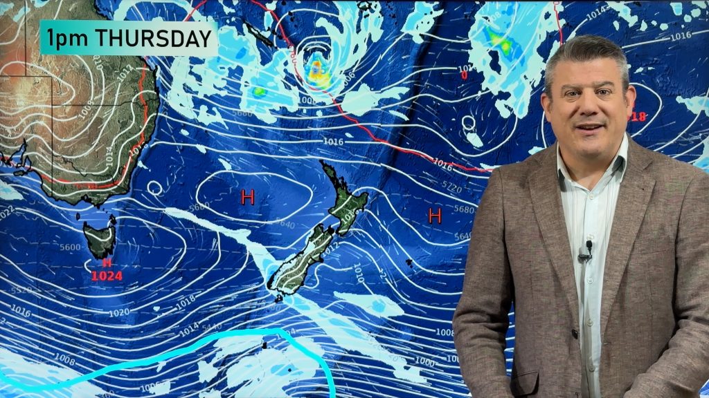
High pressure covers New Zealand today and despite a weak cold front coming in to southern NZ on Thursday more high pressure returns going into the weekend. But, there is a catch – on Monday a burst of cold air from the sub-antarctic region south of NZ will move in, bringing rain, some thunderstorms and showers, gale force winds and even a dusting of snow on the Southern Alps.
The good news, for those sick of the wind and cold, is that more high pressure comes in after it and may well linger into the long Waitangi weekend. We don’t yet have a forecast for the long weekend, but we do have a map for Waitangi Day to help make sense of what may be shaping up.
Lastly, there is a tropical depression between Vanuatu and Fiji and while it’s close to being a tropical cyclone it’s expected to fall apart before reaching NZ due to high pressure over us – but it may bring a few showers and higher humidity and heat to those in Northland this weekend (but no severe weather is forecast at this stage). For those regions dealing with the recent floods and landslides we expect much drier, warmer, weather for most of you over the coming week despite the severe weather risks further down the country this coming Monday.
Latest Video

Antarctic southerly for parts of NZ Fri & Sat
For the first time this year a southerly from off Antarctica is heading towards the South Island, followed by more…
Related Articles
Antarctic southerly for parts of NZ Fri & Sat
For the first time this year a southerly from off Antarctica is heading towards the South Island, followed by more…

Meteors – Your Eyewitness Reports!
WeatherWatch.co.nz receives meteor reports from all over New Zealand and the globe, 24/7/365. **CASUAL COMMENTS**If you’ve seen something in the…

Snow, rain showers & cold polar southerlies set to return
Friday will be a wintry day across NZ as the next cold front arrives, bringing snow to lower levels of…

