Subtropical low (yes, another one) to brush the NI, high pressure still in charge
16/03/2026 10:38pm
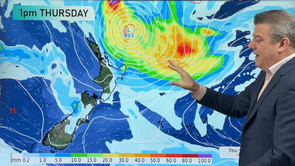
A subtropical low will power up over the next 24 hours and brush past the north-eastern corner of the North Island around Thursday and Friday, bringing some rain and a burst of wind. Then it’s gone by the weekend. We show you the latest tracking and which areas are most exposed to any potential severe weather.
But, for the most part, much of NZ remains dry or mainly dry in the coming days despite a weak cold front also coming up the South Island on Wednesday and Thursday and falling apart.
Many regions have below normal rainfall over the coming week – but the north-east corner of the North Island and the south-west corner of the South Island are most exposed to any potential severe weather.
*Programming Note:
It’s possible we won’t have a video on Wednesday, or if we do Phil may be offscreen, due to other commitments.
Comments
Latest Video

Cold weekend, frosts return with high pressure, then a low late next week
The subantarctic airflow spreads over NZ today/tonight and into Saturday, dropping temperatures nationwide. Snow flurries are possible today to lower…
Related Articles
Cold weekend, frosts return with high pressure, then a low late next week
The subantarctic airflow spreads over NZ today/tonight and into Saturday, dropping temperatures nationwide. Snow flurries are possible today to lower…

Wintry burst of weather: Snow, squally showers then sunshine & frosts
A polar change (another one!) arrives on Friday for the South Island and goes nationwide on Saturday, leaving NZ under…

Antarctic southerly for parts of NZ Fri & Sat
For the first time this year a southerly from off Antarctica is heading towards the South Island, followed by more…


Zelda Wynn on 17/03/2026 1:04am
Some rain would be welcome!
WW Forecast Team on 17/03/2026 1:07am
Very welcome – it is certainly drying out where you are!