Severe Cyclone DOVI tracking south – will fall apart over NZ bringing flood & wind damage potential (+12 Maps)
11/02/2022 5:28am

> From the WeatherWatch archives
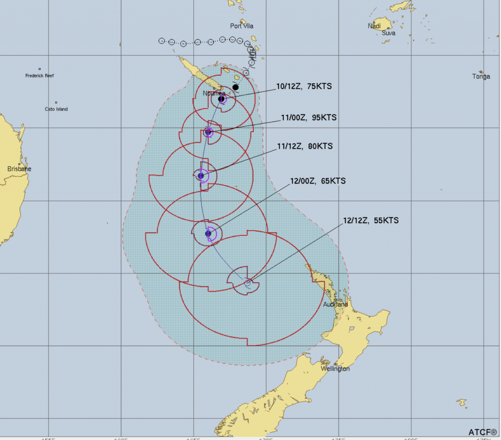
Tropical Cyclone Dovi remains a Severe Category 3 storm this evening as it tracks southwards over the Tasman Sea and toward NZ. The storm is expected to retain Cat 2 strength as it dive bombs into the NZ area this weekend from the north. While it will have a lot of intense energy as it moves southwards over the Tasman Sea it is expected to unravel over NZ – but that means it will dump a lot of rain here and as it ‘falls apart’ it will also bring areas of damaging gales into both main islands.
RAIN:
Heaviest rain looks likely to be through central NZ with 100 to 300mm possible (depending on how slow/fast Dovi moves through). This is high enough to cause slips, flooding and road closures.


Blue = Wetter than average.
White = Normal rainfall for mid February
Red/pink = Drier than average
GALES:
With the storm falling apart as it moves in – and will lose the tropical portion of Dovi’s name, so it becomes Ex-Tropical Cyclone Dovi – it becomes a bit trickier to lock in which places will get the worst winds. Precise tracking of the centre of the storm is needed and, thankfully, reliable modelling is mostly in agreement – but more fine tuning will be needed over the coming day or two.
Both islands are exposed to damaging winds for a time this weekend. Gusts may be anywhere from 100km/h to 150km/h and MetService will be issuing warnings for this.
You can find all MetService warnings and watches LIVE here. (slow loading time to open this page may be due to increased demand at MetService today).


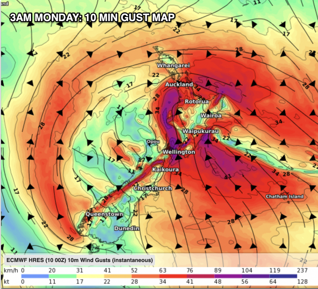

LANDFALL TIMING
Current estimates for landfall in NZ for the then ex-tropical cyclone look to be around 9pm Sunday to 3am Monday somewhere in the western North Island (give or take 6 hours at this early stage). Landfall is most likely between Waikato and Taranaki based on today’s modelling. This may still change – and because the storm is unravelling here the ‘landfall’ portion becomes less important (as severe weather will occur in both islands due to the unusual shape the storm gets once it becomes ex-tropical – a process which sees the intense wind energy at the centre of the storm fan out further and break apart into sections.

Wind maps courtesy of our friends at Weatherzone.
Rainfall map courtesy of IBM / WeatherWatch.
Comments
Latest Video

Westerly change this week, unsettled but large dry areas
Westerlies kick back in again this week which will bring a break to those in the east as far as…
Related Articles
Westerly change this week, unsettled but large dry areas
Westerlies kick back in again this week which will bring a break to those in the east as far as…

Matariki, the long weekend + the outlook for next week
Wet weather and cloud continues along the eastern side of the country with the heaviest rain now moving into northern…

More eastern rain, but a drier long weekend coming
Rain continues today along the eastern South Island and lower North Island, coming in from the east with heavy falls….


Cheryl on 12/02/2022 4:14am
Thank you very informative. Good information
Phil on 11/02/2022 8:08am
BRILLIANT video on upcoming cyclone, makes alot of sense on how it works. Thanks heaps
Robina Reid on 11/02/2022 12:27am
We are on the cook strait ferry Mon arvo😱
WW Forecast Team on 11/02/2022 1:14am
Good luck with that! Hopefully Monday will have significantly lighter winds than Sunday.
Cheers 🙂
WW
Leo on 10/02/2022 10:29pm
Bugger !!! Hope it’s not too intense. These sort of storms can produce very intense wind gusts. Stay safe all