Reasonably settled today, strong winds and rain this weekend
13/05/2025 10:59pm

> From the WeatherWatch archives
Situation
Yesterday’s cold front has moved away out to the east and in behind high pressure has slotted in over the country. A northwesterly airflow sets up tomorrow and Friday, strengthening from the north on Saturday.

Rain, temperatures, winds
Wet weather isn’t a big feature today but we do have a shower or two for the eastern and upper North Island, this evening a few light showers pick up for the West Coast and rain moves into Fiordland overnight.
Temperatures a bit cooler today for the South Island only reaching into the low teens for some, the upper North Island is warmer with highs in the late teens. Tomorrow and Friday it’s warmer in the east as the aforementioned northwesterly airflow plays more of a role.
Winds are not strong today although coastal North Otago through into coastal Canterbury sees east to northeasterly winds freshen a little this afternoon. Overnight north to northwesterly winds pick up through Cook Strait and about coastal Fiordland / Stewart Island.
Upcoming potential severe weather
All eyes on this weekend. We start on Saturday with a strengthening northerly airflow, winds rising to gale force in the usual spots i.e. through the inner South Island in the east and through Cook Strait, also along the West Coast. Strong winds likely for the western North Island on Sunday. This all ahead of a low moving in from the Tasman Sea and cold front heading in from the southwest, the low crosses over the lower South Island later on Saturday moving from west to east.
Heavy rain for the West Coast later on Saturday with thunderstorms possible, this rain moves into the North Island on Sunday although it would have eased a bit by this stage going by current modelling. Strong southwesterlies spread up the east coast of the South Island early on Sunday for a time, currently the southwest component of this system doesn’t look to have much guts to it in terms of potential snow up high or wet weather in general for the east but it’s something we’ll keep an eye on as we move forward.
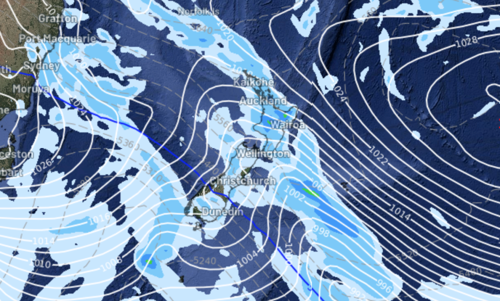
Main story image: Rain / MSLP Saturday 17th May 2025 9:00pm – GFS Weatherzone.com.au
Latest Video

Cold weekend, frosts return with high pressure, then a low late next week
The subantarctic airflow spreads over NZ today/tonight and into Saturday, dropping temperatures nationwide. Snow flurries are possible today to lower…
Related Articles
Cold weekend, frosts return with high pressure, then a low late next week
The subantarctic airflow spreads over NZ today/tonight and into Saturday, dropping temperatures nationwide. Snow flurries are possible today to lower…

Wintry burst of weather: Snow, squally showers then sunshine & frosts
A polar change (another one!) arrives on Friday for the South Island and goes nationwide on Saturday, leaving NZ under…

Antarctic southerly for parts of NZ Fri & Sat
For the first time this year a southerly from off Antarctica is heading towards the South Island, followed by more…

