Rain/Wind to ease, frosts and colder, drier, weather moving in
20/04/2026 11:55pm
Low pressure will continue to drift eastwards away from the North Island over the next 24 hours, with wind and rain continuing today, especially around central NZ/lower North Island, then easing going into tonight and tomorrow.
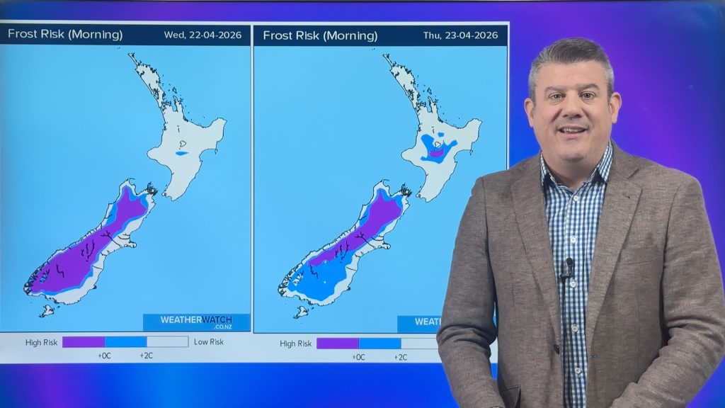
High pressure is moving into NZ with lighter winds and drier skies for most, locking in the colder air and that will lead to frosts inland through the South Island’s interior (although not for everyone) and a general reduction in overnight temperatures (and some daytime temps too).
But there may be some showers/areas of rain that may pop up at the top of the North Island this week – we’ll keep you posted in our next update on that.
For now, many places should see an improvement to their weather in the coming days – but the chance of isolated thunderstorms, downpours and showers/rain continues for today around eastern NZ but also other parts of the North Island.
Latest Video

Polar airflows set to bring cold weekend to NZ
Nor-west winds will be building over parts of NZ going into Thursday with rain on the West Coast becoming heavy…
Related Articles

Wind, rain, showers & a noticeable temperature drop for all
It will be a colder weekend right across NZ as a sub-Antarctic southerly blows through, bringing frosts, snow flurries and…
Polar airflows set to bring cold weekend to NZ
Nor-west winds will be building over parts of NZ going into Thursday with rain on the West Coast becoming heavy…

Update on incoming cold change for NZ
High pressure still covers NZ but that will slide offshore as we go into Friday and the weekend as a…

