On today’s menu: warmth, strong winds, rain and eventually a temperature drop
7/05/2025 10:27pm

> From the WeatherWatch archives
Situation
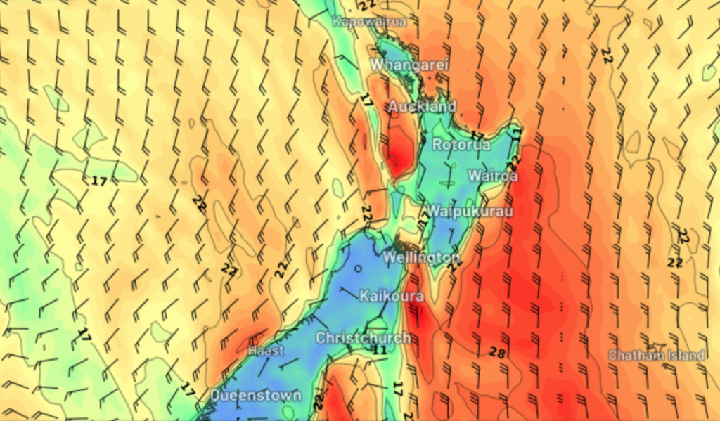
A cold front moves onto the lower South Island this afternoon with a strong northerly airflow ahead of it, the front reaches the North Island on Friday and transforms into an occluded front as it taps into some subtropical moisture from the northwest.
Heavy rain is likely for western parts of both Islands as this front moves north, more details below.

Rain
Expect showers to increase for the northeast of the North Island today, there may be the odd isolated heavy fall. Later today and overnight showers start to appear for other western regions. Showers for the West Coast with rain south of Greymouth and perhaps even some thunder, rain becoming more torrential for Fiordland from late afternoon then slowly moving north overnight. Spits of rain for Southland pick up later this afternoon then, rain moves into Otago overnight. Finally Nelson and Marlborough (more so the Sounds) sees the odd shower from this afternoon, turning to rain overnight.

Temperatures
Afternoon highs in the late teens or early twenties for many today, noticeably cooler for the South Island on Friday.
Winds
Strong to gale northerly winds are still the plan of attack for inland areas of the South Island in the east today, overnight and into Friday morning expect strong to gale northerlies for central New Zealand / the lower North Island, especially through Cook Strait. Southerlies get strong for coastal Canterbury late Friday morning then late afternoon or evening for the lower North Island as a front moves through.

Upcoming potential severe weather
Heavy rain is possible today for South Westland but it’s not till late afternoon that rain rates really pick up for Fiordland, heavy rain gradually moves north with a front this evening and overnight. Friday has the potential to deliver heavy rain for many North Island areas in the west: Taranaki, Central North Island, Northland and perhaps western East Cape later in the day especially.
Strong to gale northerly quarter winds will also be of concern for the inner South Island today and then through Cook Straight overnight / tomorrow morning, although many coastal parts of the North Island will likely see blustery northerlies on Friday. Strong southerlies freshen up for coastal Canterbury later on Friday morning reaching the lower North Island by evening.
For more details on upcoming potential severe weather please visit this page here.
Comments
Latest Video

Cold weekend, frosts return with high pressure, then a low late next week
The subantarctic airflow spreads over NZ today/tonight and into Saturday, dropping temperatures nationwide. Snow flurries are possible today to lower…
Related Articles
Cold weekend, frosts return with high pressure, then a low late next week
The subantarctic airflow spreads over NZ today/tonight and into Saturday, dropping temperatures nationwide. Snow flurries are possible today to lower…

Wintry burst of weather: Snow, squally showers then sunshine & frosts
A polar change (another one!) arrives on Friday for the South Island and goes nationwide on Saturday, leaving NZ under…

Antarctic southerly for parts of NZ Fri & Sat
For the first time this year a southerly from off Antarctica is heading towards the South Island, followed by more…


josh on 7/05/2025 10:30pm
thanks for this guys. missing the videos but hope Phil the weather guy is recovering well.
at least not much for Canterbury and wellington this week.