Oma downgraded to Ex-Tropical Cyclone but about to do U-turn back north into the tropics (+7 Maps)
23/02/2019 2:45am

> From the WeatherWatch archives
UPDATED 3:45pm Saturday — Cyclone Oma has this afternoon been downgraded to an Ex-Tropical Cyclone by Australian forecasters at the Bureau of Meteorology (BoM). The remaining tropical depression is also about to do a 180 degree turn and head back northwards into the tropics, either back where the storm came from or further north over the Coral Sea due to an enormous high pressure system moving over the Tasman Sea area and expanding in the days ahead, says WeatherWatch.co.nz.
This large high will cross New Zealand over next week, followed by another high, both of which will help guide Oma back northwards (and away from NZ) and also likely eventually help pull the storm apart. The high will balloon out over the Tasman Sea with Oma above the northern portion of the high being pushed slowly back northwards. Winds at higher levels in the atmosphere from the high pressure system should weaken the low too – which is what has happened today, Saturday.
WeatherWatch.co.nz says as of Saturday Oma is centred about the same length of New Zealand (1600kms) away from Northland to the north west and about 650kms east of Australia’s Queensland.
Weatherzone meteorologist Ben Domensino in Australia tweeted on Friday evening that a wave of 13 metres had been recorded in Mooloolaba on the Sunshine Coast. “Wow. A maximum wave height of 13 metres was just registered off Mooloolaba! If accurate, this is the biggest wave recorded by this buoy since it started operating in 2000″ he wrote.
A big surf will continue for days with Ex-Cyclone Oma likely to remain stuck in place and slowly turning and backtracking northwards. As of 11am Saturday NZDT Cyclone Oma was still a Category 2 Cyclone but BoM has since downgraded it, saying Oma “is undergoing extratropical transition” was likely to be “de-named ” today.
WeatherWatch.co.nz says Oma will not be directly impacting New Zealand.
Wow. A maximum wave height of 13 metres was just registered off Mooloolaba! If accurate, this is the biggest wave recorded by this buoy since it started operating in 2000. pic.twitter.com/s1yvX6AYRR
— Ben Domensino (@Ben_Domensino) February 22, 2019


Computer Models/Forecasters both agree Oma is weakening and will fall apart over the Coral Sea, or head back northwards as a weaker tropical storm…
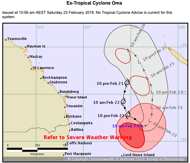
ABOVE: BoM (Australian Government) tracking
BELOW: JTWC (US Government) tracking

 – The “spaghetti” models, shown here by website cyclocane.com show the blocking nature of the high south over the Tasman Sea with not one model picking a New Zealand track, or even a Tasman Sea track. Oma may well be pushed northwards as a tropical depression and linger for at least another week. Beyond a week it’s hard to say if the storm will completely fall apart, or, regenerate again closer to northern Queensland or the northern Coral Sea area.
– WeatherWatch.co.nz
Comments
Latest Video

NZ: 8 Day outlook as gales & rain ease, high pressure builds
Damaging wind gusts and heavy rain will continue to affect some parts of the North Island and brushing Marlborough today…
Related Articles
NZ: 8 Day outlook as gales & rain ease, high pressure builds
Damaging wind gusts and heavy rain will continue to affect some parts of the North Island and brushing Marlborough today…

Pockets of hit & miss heavy rain, snow moves northwards
Low pressure continues to slowly move across the upper North Island and for some that will bring the sun out,…

Slow go for northern low & southern cold
For the next few days low pressure will crawl over the upper North Island, driving in rain as far south…


Guest on 23/02/2019 2:46am
In the march 1993, cyclone Roger stalled offshore from Fraser Island and waves of 13m+ were recorded at Caloundra, about 20 klms south of Mooloolaba at the entrance to Moreton Bay.
This forced the closure of the Port of Brisbane.
And like Oma, Roger just fizzled out after doing a similar 180 degree about turn.
Guest on 22/02/2019 11:51pm
forgot this its a wonder why theres all this hoopla a bout them in nz when they hardly come here those two by passing the NI and hitting the SI was weird those southern fronts never by pass the SI lets see if this southerly of yours does and go to the NI
Guest on 22/02/2019 11:46pm
its going to be a crap season for them unless march produces one no wonder its very very dry