Next 24 – 48 hours: South Island floods possible, MetService issues ‘red’ rain warning + Severe gales for NI (+9 Maps)
15/07/2021 8:03pm

> From the WeatherWatch archives
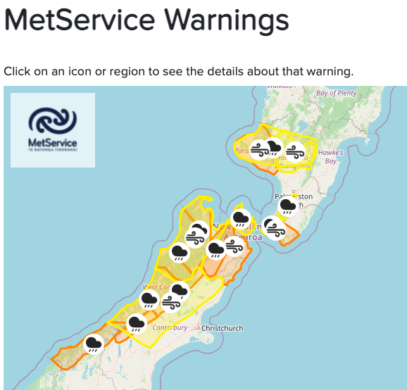
Intense rain for the northern half of the West Coast and upper South Island is forecast across Friday and Saturday (but will continue on into Sunday and Monday too, to a lesser degree).
Totals up in the mountains are 300 to 400mm over the next few days and in coastal areas 150 to 200mm is possible, with places like Westport and Hokitika (and inland from there) possibly most exposed. The bulk of this rain will fall over the next 48 hours.
The rain will be consistent and heavy enough to spillover into Nelson and Marlborough with over a month’s worth of rain possibly falling there in just the next two or so days.
Taranaki and the ranges of the lower North Island are also exposed to some big totals approaching 100mm or more in just the next day or so.
Severe north west gales will also be blowing for a time later today and across Saturday. WeatherWatch.co.nz has been saying all weeks gusts to 130km/h are possible and may even go higher to 150km/h along the eastern North Island ranges. This is similar to MetService’s severe gale warnings which are saying 140km/h possible in the lower North Island.
Crown forecaster MetService has issued a red rain warning for parts of Westland (north of the glaciers, not south as so main rain events often are). A red rain warning is MetService’s highest and most severe warning. They’ve issued a number of wind and rain warnings for this event. You can now find all MetService warnings and watches LIVE on the WeatherWatch site simply by clicking/tapping here.
STAY ON TOP OF YOUR LOCAL RAINFALL FORECASTS:
For local rainfall updates – including hourly intensity and peak rain times – check out the IBM powered weather graphs at www.RuralWeather.co.nz or your local WeatherWatch forecast.


Latest Video

NI low pressure, SI polar change
Low pressure will move over the upper North Island this week, bringing hit and miss pockets of heavier rain into…
Related Articles
NI low pressure, SI polar change
Low pressure will move over the upper North Island this week, bringing hit and miss pockets of heavier rain into…

Rain & showers this weekend, colder change next week
Some places will warm up over the next day or so as a nor’wester out of Australia moves across NZ,…

Temperature changes for some regions ahead of heavy West Coast rain
A nor-wester is about to kick in and it’s coming from out of Australia, boosting temperatures in some regions going…

