Low pressure engulfs NZ, colder air coming but first more downpours & T-storms (+8 Maps)
11/08/2019 9:02pm

> From the WeatherWatch archives
Today’s weather improves for some but we’re not finished yet with these complex low pressure systems, now the colder air is about to arrive.
For Monday the weather improves quite a bit in some southern places with the South Island calmer, sunnier and drier (although some rain possible in Nelson and Marlborough still). The North Island, on the other hand, is still dealing with squally downpours, some with hail and thunder, right along the western coastline and northern regions too. These downpours step up in intensity today ahead of the colder air flow coming in at the end of this event. Also the strong westerlies in the upper North Island may reach gale force in some gusts today and will also help continue to whip up marine conditions in the west, with dangerous waves over seven metres on some northern western beaches.
As we mentioned last week a storm well south of New Zealand will today and tomorrow influence our weather pattern without directly hitting us. The Antarctic southerly behind this event is coming from the iceshelfs but will be mostly be dredged up to our south east. However, the South Island is impacted by the colder than average air and wind chills below zero are expected with showers, sleet and even some low level snow on Tuesday.
On Tuesday the snow flurries look mostly light and only in some parts of Southland and Otago but combined with windchill it will be miseable for newborn stock.
Coldest air peaks on Tuesday and Wednesday and we may see snow flurries as low as 100 or 200m for a time in Southland and Otago here and there. There’s even a chance of a some rain/snow mix to sea level in Milford Sound. Snow totals will be lower than previous days, this is more about the cold.
Cold air will go northwards too. It’s not a major set back but for most regions we have a cold or colder Tuesday and Wednesday coming up. Many South Island centres have single digit highs on Tuesday and Wednesday especially Southland, Otago and Canterbury. Queenstown has highs of +6 with snow flurries possible next couple of days and and a dry but cold high of +4 by Wednesday.
Even Wellington may struggle to reach 10+ on Wednesday with the day expected to hover mostly around 9C.
Northern NZ isn’t so much impacted, with Auckland dropping from highs around 15 or 17 to just 13 or so on Wednesday.
CURRENT SET UP – Yellow – High air pressure, Purple = Low air pressure
NOON TUESDAY – The Antarctic portion is being dredged up. While the coldest of this air only just brushes the lower South Island many regions have a temperature drop this Tuesday and/or Wednesday.
NOON WEDNESDAY – Peak cold surges up New Zealand, failing to reach the very north but certainly dropping temperatures for many in the south and south east. Warmer air from Australia starts to move our way by late Wednesday and into Thursday/Friday.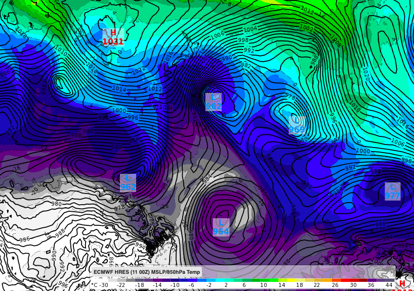


– WeatherWatch.co.nz
Latest Video

Wintry burst of weather: Snow, squally showers then sunshine & frosts
A polar change (another one!) arrives on Friday for the South Island and goes nationwide on Saturday, leaving NZ under…
Related Articles
Wintry burst of weather: Snow, squally showers then sunshine & frosts
A polar change (another one!) arrives on Friday for the South Island and goes nationwide on Saturday, leaving NZ under…

Antarctic southerly for parts of NZ Fri & Sat
For the first time this year a southerly from off Antarctica is heading towards the South Island, followed by more…

Meteors – Your Eyewitness Reports!
WeatherWatch.co.nz receives meteor reports from all over New Zealand and the globe, 24/7/365. **CASUAL COMMENTS**If you’ve seen something in the…

