Low blow! Burst of gales, severe in places, moving across the South Island today (+Animation & Maps)
20/11/2020 8:14pm

> From the WeatherWatch archives
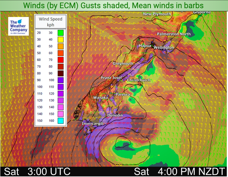
A small but potent low pressure system is brushing past Southland and Otago today, bringing severe gales as far north as central New Zealand.
While windy nor’westers gusting up to 120km/h may affect the northern Southern Alps and ranges of the lower North Island it’s the main belt of severe gales around the centre of the low further south that could be more damaging.
The very worst of the winds will be just offshore to the south east of Dunedin, but the belt of gales brushes over Southland and Otago with gusts over 130km/h possible in more exposed areas/usual wind tunnels.
This wind covers a fairly narrow area but brushes over Southland and Otago (especially coastal areas and the ranges closest to the coastlines).
Not all parts of the South Island will be windy today.
WeatherWatch.co.nz is in agreement with all MetService warnings and watches issued at the moment – which you can find here: www.weatherwatch.co.nz/maps-radars/warnings/metservice
We advise you keep up to date with their warnings, plus the latest Hourly local forecasts here at WeatherWatch.co.nz, our free WeatherWatchNZ App or at www.RuralWeather.co.nz.


WeatherWatch.co.nz – New Zealand’s Weather News Authority
RuralWeather.co.nz – Backing Farmers & Growers who feed New Zealanders
Latest Video

Frosts, late week rain & another cold weekend coming
High pressure will cross NZ over the next few days meaning more cold nights/mornings with frosts, but a nor’wester will…
Related Articles
Frosts, late week rain & another cold weekend coming
High pressure will cross NZ over the next few days meaning more cold nights/mornings with frosts, but a nor’wester will…

NZ: Cold & windy, then calm & frosty
Downpours, some squally with the chance of thunderstorms and even small tornadoes are possible for parts of NZ over Friday…

WeatherWatch App launches real-time local lightning tracker
A bolt out of the blue! WeatherWatch has launched a live, real-time lightning tracker, enabling Kiwis to gain access to data provided by the…

