
> From the WeatherWatch archives
#YASI — Cyclone Yasi has been downgraded further to a category 2 tropical cyclone, reduced from the category 5 it reached last night.
However WeatherWatch.co.nz says the winds are still destructive – and despite the wind easing the rain will not, with torrential rain continuing to fall across much of Queensland.
Australia’s Bureau of Meteorology says Yasi will continue to weaken as it moves in a west-southwesterly direction towards the Georgetown area during the morning.
As of 10am NZT winds were gusting to 155km/h, down from 205km/h at 8am and down from 295km/h at 3am.
Full details below…
Yasi made landfall around 3am at Mission Beach, about 50km south of Innisfail, Queensland reports WeatherWatch.co.nz.
Around 6am the cyclone lost its impressive ‘eye’ and the air pressure in Cairns is now quickly rising – evidence that the worst of the cyclone is now leaving the coastline and headed inland.
Over the next 12 to 18 hours the system will continue to rapidly weaken wind-wise however torrential rain will remain.
HUGE SEAS
Queensland Premier Anna Bligh says a wave last night broke the record books… again. It was just hours after the record had previously been broken.
On Wednesday afternoon a wave measuring 6.6 metres was recorded off the coast of Townsville. At the time it was biggest wave in the area since records began in the 1970s.
Just a few hours later another wave smashed that record, coming in at a massive 9.5 metres.
STORM SURGE NOT AS BAD AS EXPECTED
Yasi last night started to slow down as it approached the Queensland coast, which would have been favourable to the area.
The late arrival meant the storm surge of 7 metres peaked at low tide – in effect removing around 3 metres of height from the sea.
However the slower storm speed meant torrential rain category 5 hurricane force winds lingered for longer over the coastline – causing more catastrophic damage.
Details of Severe Tropical Cyclone Yasi
- Details of Tropical Cyclone Yasi at 7:00 am EST:
- Centre located near…… 18.9 degrees South 144.2 degrees East
- Location accuracy…….. within 35 kilometres
- Recent movement………. towards the west southwest at 36 kilometres per hour
- Wind gusts near centre… 155 kilometres per hour
- Severity category…….. 2
- Central pressure……… 979 hectoPascals
Queensland Premier Anna Bligh told reporters earlier this morning that once the storm’s centre hit we would only be able to sit and wait for the storm to pass. Her message was to both the public of Queensland who still had the means of hearing or viewing her statement and to the rest of Australia, New Zealand and the world waiting to hear the latest on conditions in the area.
Premier Bligh told reporters that very little information would be available until day breaks and even then it would only trickle through.
The cyclone may still be severe enough to stop any emergency services from getting in to the area, and with severe gales expected to buffet the region until later in the day it may be some time before pictures come through from the ground or air of the regions worst affected.
WeatherWatch.co.nz will step up reports once day breaks across the region and more news comes to hand.
The monster cyclone is stronger than Hurricane Katrina was when she hit New Orleans, something WeatherWatch.co.nz predicted early on Wednesday night.
It will be days before the storm falls apart completely with WeatherWatch.co.nz predicting that the storm will bring heavy rain to parts of the desert as it travels towards Perth. Something almost unheard of.
Observations as of 8am NZT
- Lucinda (near landfall) – 111km/h gusting 148km/h
- Cairns – 41km/h gusting 59km/h (no longer gale)
- Townsville – 82km/h gusting 107km/h
- Numerous weather stations are no longer operational.

Severe Tropical Cyclone Yasi, Category 5, as of landfall at 3am NZT

Latest Tracking – press F5 to refresh
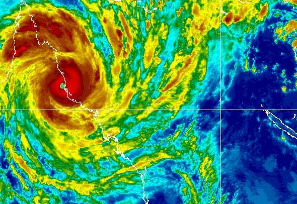
A very rare sight – the eye of a category 5 cyclone fully inland and fully intact at 4am NZT image / MTSAT
Latest Video

Colder nights/mornings, polar change coming Sun/Mon
The nights and mornings ahead will be colder in a number of regions – but an even colder change is…
Related Articles
Colder nights/mornings, polar change coming Sun/Mon
The nights and mornings ahead will be colder in a number of regions – but an even colder change is…

Frosts, clearer skies coming – severe weather possible this weekend
High pressure lies south of NZ today and that placement encourages a colder south-east wind into the North Island bringing…

NZ: 8 Day outlook as gales & rain ease, high pressure builds
Damaging wind gusts and heavy rain will continue to affect some parts of the North Island and brushing Marlborough today…

