High pressure, cold fronts & a potential offshore tropical storm
24/02/2026 11:00pm
We still have summer weather left – but as end the month of February and kick off March we do have a couple of cold fronts that will definitely bring an Autumnal feeling to most regions around Sunday and Monday.
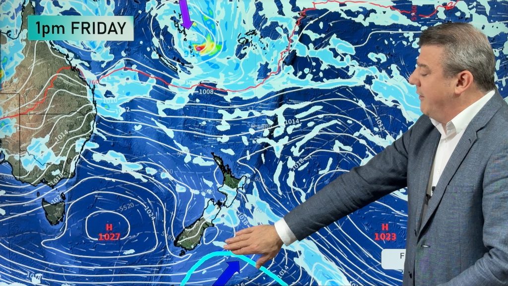
The first cold front comes in tomorrow/Thursday – then moves into central parts of the country (Upper SI, lower NI) on Friday with some showers or patchy rain. By Friday northern and southern NZ should be dry or mainly dry. But also on Friday a tropical low near Vanuatu does have the potential to become a tropical cyclone – and it will likely strengthen this weekend out at sea north of New Zealand.
By Sunday a strong high pressure zone will be offshore west of the lower South Island – this placement will usher in a colder/cooler southerly, especially for Monday March 2nd. That’s also when we expect the tropical low to be north-east of NZ where, hopefully, it will remain – falling apart around the Chatham Islands next week as it merges with other low pressure. Then, we expect that next high pressure system to move into NZ bringing more settled weather.
Quite a few moving parts – but not a lot of severe weather risks for NZ at this stage.
Latest Video

Westerly change this week, unsettled but large dry areas
Westerlies kick back in again this week which will bring a break to those in the east as far as…
Related Articles
Westerly change this week, unsettled but large dry areas
Westerlies kick back in again this week which will bring a break to those in the east as far as…

Matariki, the long weekend + the outlook for next week
Wet weather and cloud continues along the eastern side of the country with the heaviest rain now moving into northern…

More eastern rain, but a drier long weekend coming
Rain continues today along the eastern South Island and lower North Island, coming in from the east with heavy falls….

