Large low = chopping & changing forecasts next several days
16/04/2026 11:29pm
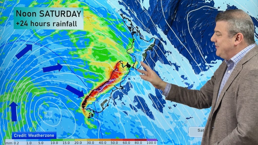
Expect weather forecasts to shift around a bit over the weekend and across next week in some regions as a large low pressure zone engulfs the New Zealand area with thunderstorms, downpours, heavy rain and wind… along with large dry areas, and calm zones too.
Large lows in NZ, especially in Autumn and Winter, are well known for producing instability which can “break” forecasts, with downpours developing quickly out of blue sky, or thunderstorms that are forecast for you eventually developing in a region nearby instead. The larger the low, the more likely this is to happen.
NZ’s mountains and ranges further complicate things. We always strive to be as accurate as we can, but sometimes simply knowing that upcoming forecasts may not be as precise can also be helpful, and we encourage people to closely monitor the rain radar each day over the next several days if wet weather matters to you, because we do expect some local differences to what is generally forecast.
We break down the low moving in, where it may track and how long it might linger around New Zealand for and which regions are currently exposed to severe weather potential.
There are possible severe weather risks in both main islands, but as you will see, not everyone will have rough weather, some may be quite dry with little to notice.
Latest Video

Tracking the showers & a potential wintry blast late next week
NZ is on the edge of high pressure with anticyclones moving through at times over the next several days bringing…
Related Articles
Tracking the showers & a potential wintry blast late next week
NZ is on the edge of high pressure with anticyclones moving through at times over the next several days bringing…

Some polar airflows but more high pressure to affect NZ’s weather
Showers are in the forecast over the next several days, we track where and when they occur – but there…

Tracking the showers & colder changes
High pressure isn’t over NZ, but is nearby – and it’s affecting our airflows and who gets wet weather and…

