‘It doesn’t get much worse than this’ – Category 5 Cyclone Harold aiming for Vanuatu today (+10 Maps)
5/04/2020 7:57pm

> From the WeatherWatch archives
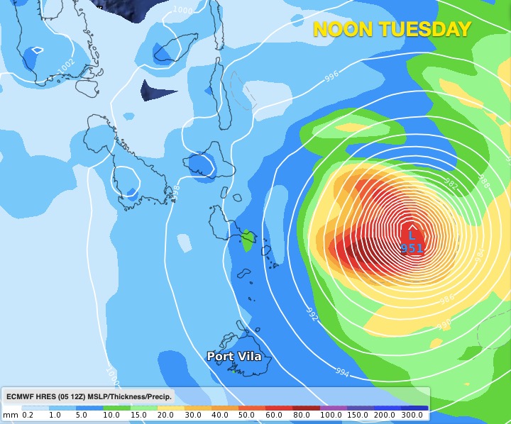
A worst case scenario is unfolding for Vanuatu today with Cyclone HAROLD reaching Cat 5 overnight, the highest level on the cyclone scale.
The violent and historical storm is now directly approaching Vanuatu.
It currently has SUSTAINED winds of 220 kmh (120 kt) with GUSTS to 270 kmh (145 kt).
HAROLD is slowly crawling towards Vanuatu in an easterly direction, moving at just 2 kmh (human walking speed is about 8 kmh).
According to the US Joint Typhoon Warning Center (JTWC) satellite imagery shows the centre of HAROLD has a wobbly, but tightly packed eye. It is generating waves of 11 metres (36 feet).
“For those in Vanuatu it doesn’t get much worse than this, a Category 5 tropical cyclone forecast to make direct landfall in a South Pacific nation” says WeatherWatch.co.nz head forecaster Philip Duncan. “There has been a decent build up to this storm with plenty of coverage but with the Covid-19 situation as well as a major Cat 5 cyclone makes this a much more complicated situation”.
Mr Duncan says HAROLD is slow moving over very warm waters but one positive is that on Tuesday it pulls away from Vanuatu quite quickly.
Fiji has a close call and some islands south of the main island will be exposed. Nadi remains outside most of the severe portion of weather on Wednesday but those in Fiji should closely monitor.
There is no direct threat for either New Caledonia or New Zealand.
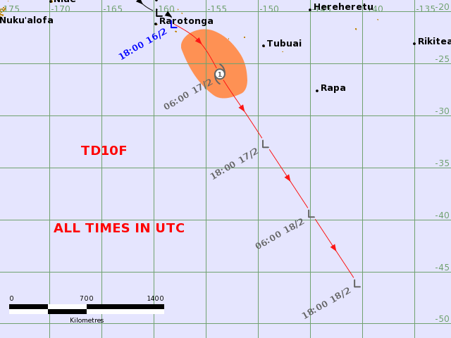
LIVE TRACKING MAPS (auto updated via Fiji Met)
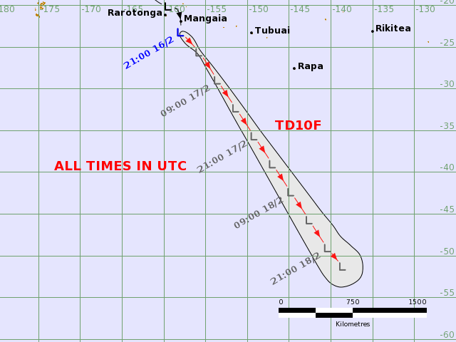
JTWC TRACKING: (Zoom in to see more detail)

TIMING / LOCATION FOR VANUATU & FIJI:


SIGNIFICANT WAVE HEIGHT: 2PM MONDAY:

Latest Video

NI low pressure, SI polar change
Low pressure will move over the upper North Island this week, bringing hit and miss pockets of heavier rain into…
Related Articles
NI low pressure, SI polar change
Low pressure will move over the upper North Island this week, bringing hit and miss pockets of heavier rain into…

Rain & showers this weekend, colder change next week
Some places will warm up over the next day or so as a nor’wester out of Australia moves across NZ,…

Temperature changes for some regions ahead of heavy West Coast rain
A nor-wester is about to kick in and it’s coming from out of Australia, boosting temperatures in some regions going…

