How might Donna affect New Zealand? It comes back as Donna Mark II
8/05/2017 8:12pm

> From the WeatherWatch archives
Severe Cyclone Donna is heading towards New Zealand but a direct hit looks unlikely and the storm is going to weaken significantly before reaching northern areas.
However – it’s what may happen to Donna AFTER she leaves the tropics that may have more of an impact on New Zealand.
As with all tropical cyclones they technically lose their ‘tropical’ status (warm core) once they leave the warm waters of the tropics. As they approach northern New Zealand the storm goes through a big process of change. There’s no need to give you a science lesson but in short the storm goes from a warm centre to a cold one and this process can see lows rapidly deepen again within the New Zealand area.
The good news is that if this does happen it’s very likely to happen east of the North Island at sea. But it may deepen and grow big enough for a time to reach back towards the country.
Donna may also link up to some degree with a weak system crossing New Zealand and help encourage more rain – but most data we rely on suggests Donna’s rains will be quite separated to the rain over New Zealand. The concern will be if Donna merges with it, which is still possible although not currently forecast.
Unless the tracking changes we don’t see too many severe weather risks with Donna in New Zealand as of today, but as with any potent storm like this the path it takes may well change – so everyone in northern and eastern New Zealand should be up to date with the progress of Donna up until the weekend.
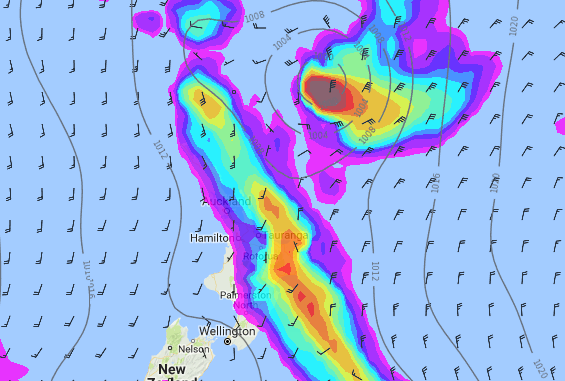 Donna just to the north east of NZ on Friday morning. Current thinking is that it isn’t going to directly impact New Zealand.

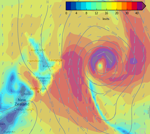
A whole new beast – Donna transforms into a bigger, more aggressive system east of the North Island on Saturday morning.
 The worst of Donna’s winds will be at sea on Friday evening – but depending on how close to NZ the low tracks (and how much it deepens again) will affect how windy it gets (or doesn’t get) on land.
 Larger swells move into Bay of Plenty on Friday night but it’s really Saturday that big seas will form east of the North Island.
 Latest tracking from JTWC (US Government).
– WeatherWatch.co.nz
Latest Video

NZ: 8 Day outlook as gales & rain ease, high pressure builds
Damaging wind gusts and heavy rain will continue to affect some parts of the North Island and brushing Marlborough today…
Related Articles
NZ: 8 Day outlook as gales & rain ease, high pressure builds
Damaging wind gusts and heavy rain will continue to affect some parts of the North Island and brushing Marlborough today…

Pockets of hit & miss heavy rain, snow moves northwards
Low pressure continues to slowly move across the upper North Island and for some that will bring the sun out,…

Slow go for northern low & southern cold
For the next few days low pressure will crawl over the upper North Island, driving in rain as far south…

