Heavy rain and heavy snow coming – we have the latest numbers (+5 Maps)
27/05/2019 11:57pm

> From the WeatherWatch archives
A late Autumn storm is going to produce heavy rain and heavy snow in the days ahead – but some will stay mostly dry.
The bulk of the rain in the days ahead will be on the West Coast with over 300mm possible by the weekend, on top of what has already fallen.
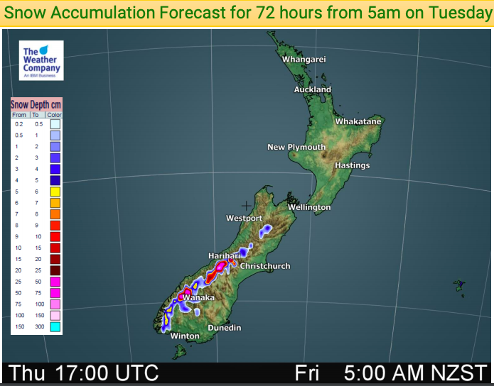
By late Thursday and across Friday this will turn as snow above 400m in the South Island and snow falls on Friday and Saturday over the North Island. All ski fields get snow by late week or the weekend.
Not everyone has rain though, as you can see in the first map below showing rainfall totals between now and midnight Saturday. The areas circled are mostly dry.
RAINFALL ACCUMULATION – Noon Tuesday May 28 to Midnight Saturday June 1:


– WeatherWatch.co.nz
Comments
Latest Video

Wintry burst of weather: Snow, squally showers then sunshine & frosts
A polar change (another one!) arrives on Friday for the South Island and goes nationwide on Saturday, leaving NZ under…
Related Articles
Wintry burst of weather: Snow, squally showers then sunshine & frosts
A polar change (another one!) arrives on Friday for the South Island and goes nationwide on Saturday, leaving NZ under…

Antarctic southerly for parts of NZ Fri & Sat
For the first time this year a southerly from off Antarctica is heading towards the South Island, followed by more…

Meteors – Your Eyewitness Reports!
WeatherWatch.co.nz receives meteor reports from all over New Zealand and the globe, 24/7/365. **CASUAL COMMENTS**If you’ve seen something in the…


Guest on 28/05/2019 12:28am
why is the west coast and the eastern bay getting all this rain in the past the heavy rain use to be well spread but not this season and you could add NP and wellington to the mix