
Gale westerlies surge next several days
31/08/2026 12:10pm
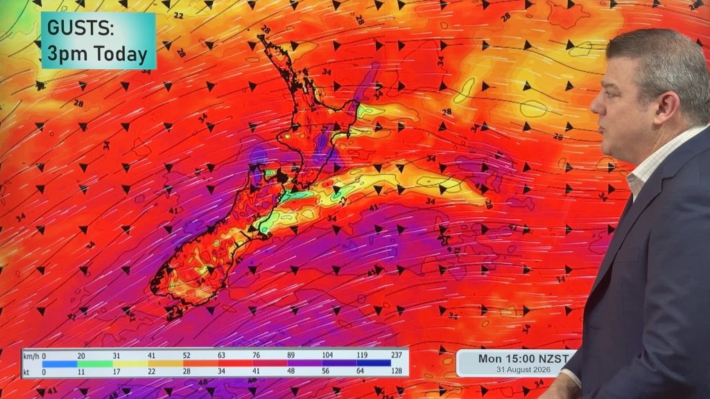
Severe gales will rush over NZ at times this week and this weekend as we continue to see a strengthening of the spring weather pattern.
It’s a wintry day in the South Island today with lower level snow around Southland and Otago in passing showers and a drop in temperatures tracking northwards, but this cold change won’t really impact the North Island as much and by late Tuesday it gets pushed off most of the country other than the Chatham Islands.
The westerly winds will surge off and on this week, bringing gales with damaging gusts and power outage potential – we track the peaks of these winds and where they will be.
We have your detailed NZ big picture forecast through to this Sunday.
*Programming Note:
– Our September ClimateWatch update will be issued this Wednesday afternoon.
Westerly winds will ramp up at times this weekend and this coming weekend for southern coast parts of Australia, but especially Tasmania and Victoria which will be most exposed to this windier and changeable weather.
The West Coast of Tasmania has over 100mm forecast, but rainfall numbers taper off for Vic and southern NSW, although some heavier rain is likely around the Victorian Alps.
WA also has low pressure developing later this week and along with some polar air that will produce some heavier downpours later this week and weekend.
The westerly flow will also boost temperatures in eastern/coastal NSW where temperatures may reach 30 degrees (or close to it) over the coming week.
If you’re in the tropics the forecast is looking quite settled with a few coastal showers, otherwise mainly dry with light winds and an increase in tropical heat for the top half of NT, FNQ and the Kimberley region in WA.
Latest Video
Southerly change, T-Storms & Frost risks
Low pressure continues to cross NZ today, potentially bringing a few thunderstorms with it overnight and into Friday for the…
Related Articles
Cold southerly about to blow through
A wintry change is moving into NZ, although still warm nor’westers ahead of it today in many regions. Over the…
Winter snap, strong winds, downpours, alpine snow
It’s still warm in a number of places but a colder change is coming nationwide by late week with a…
Hotter, but Wintry Snap coming late week
Temperatures will soar into the mid to late 20s early week but single digits for some by late week as…

