Full update on Severe Tropical Cyclone Pam – now Cat 5 (+ six maps)
12/03/2015 11:34pm

> From the WeatherWatch archives
Vanuatu is today in the firing line for Severe Tropical Cyclone Pam, which is now a monster Category 5 storm and poses serious threat to lives and property over the following 24 hours.
According to the Joint Typhoon Warning Centre winds from Pam may have sustained speeds of 280km/h at the centre with gusts over 330km/h.
It will slowly cross Vanuatu region today and considerable damage is likely.
Tomorrow Pam will start to clear Vanuatu and affect parts of eastern New Caledonia as it starts to slide south towards the North Island of New Zealand.
Head weather analyst Philip Duncan said that while computer models continue to place the centre of the low to the east of New Zealand on Monday he says the damaging winds may brush north eastern parts of the North Island. “This is a huge storm and will be far too close for comfort – meaning eastern areas like East Cape, Gisborne, eastern Bay of Plenty and northern Hawkes Bay may well be exposed to damaging winds on Monday”.
“No one should be underestimating the power of this storm – if the weather isn’t severe on Monday it will not be because the storm wasn’t there, it will be that it narrowly missed us…the weather version of dodging a bullet if that eventuates”.
Computer models have been switching around all week but the general theme amongst them tends to place the very eastern coastline of the North Island at highest risk for any potential severe weather from Northland to Wairarapa, but especially East Cape and Gisborne area.
Incredibly rough and dangerous seas will pound the east coast developing later on Sunday and lasting, for some eastern areas, most of next week.
“This cyclone has so much power and energy in it that the sheer size of it rotating means that it will occasionally ‘wobble’ left and right – which is why precisely predicting the path of the damagng portion of the storm is so tricky. But certainly the north eastern side of the North Island is exposed to severe weather from Pam, mostly on Monday”.
WeatherWatch.co.nz says Pam is unlikely to be a repeat of Bola floodingwise – but that wind damage, slips and flooding are all a possibility around Gisborne and East Cape based on data at this moment.
New Zealanders should stay up to date with all MetService severe weather outlooks, watches and warnings as Pam approaches, mostly between Sunday and Tuesday, however the effects of the storm may linger for some areas well into next week (like rough seas to the east and windy southerlies for some regions).
The Chatham Islands will also be especially exposed to the storm – which may directly track over it.
– WeatherWatch.co.nz

Map at 7am Friday via Fiji Met Service.
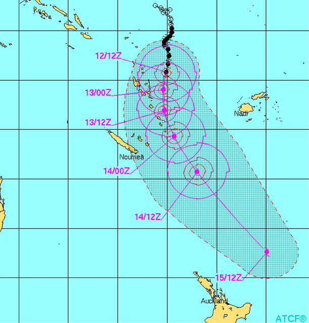
JTWC tracking of Cyclone Pam as of Friday AM NZT – please note while it seems to end shorter than previous updates this is because JTWC only track “tropical cyclones” – meaning once it’s no longer technically classed as that their updates stop. The storm may still be severe with similar strength winds as it transitions into an ex-cyclone just to the north and north east of NZ…the tracking, however, is in line with other models in our view.

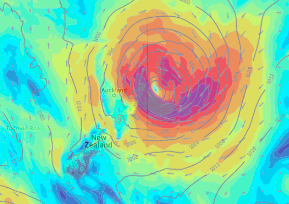
ECMWF wind and pressure map for Sunday night/Monday AM. The worst of the winds are dark green, but also the one area in white partially wrapped around the centre of the storm. Lighter green and yellow are the ‘usual’ winds we get in NZ from lows and highs etc and can be a little blustery but not damaging. You can see the distance between potentially damaing winds and general winds isn’t too great – which is why if the storm ‘wobbles’ to the west (left) a bit it could push damaging winds in closer… if it moves a little further to the east (right) then it clears NZ quite easily. A fine line with serious consequences if it drifts just a little further west towards NZ on Monday.
WeatherMap wind Map – From the maps found at WeatherWatch.co.nz here is the Monday 10am wind map. These maps are produced by different data to the ECMWF map above – and yet show a similar position and threat to New Zealand which is helpful to forecasters tracking it. This also highlights the large area of damaging winds – and the fine line between them and most of the North Island on Monday.

WeatherMap.co.nz rain map for Monday at 10am (taken from the maps page on our website) shows the bulk of the torrentail rain out at sea – but still north eastern and eastern areas of the North Island may be in for 12 to 24 hours of rain. Positive for farmers – but once again if the low jogs a little further west it could mean rain warnings are issued for places like East Cape, Gisborne and Hawkes Bay and that positive rain might lead to slips and flooding. The worst of the weather with these storms is generally in the south eastern quadrant – which is well out to sea based on these models above.

Earth.nullschool.net current wind map (which you can see in animated form on our homepage) shows Cat 5 Cyclone Pam moving in on Vanuatu this morning. The wind flow around the upper North Island is now caught up in the giant clockwise motion around Pam’s centre a stunning 3500kms away.
– WeatherWatch.co.nz
Comments
Latest Video

Cold weekend, frosts return with high pressure, then a low late next week
The subantarctic airflow spreads over NZ today/tonight and into Saturday, dropping temperatures nationwide. Snow flurries are possible today to lower…
Related Articles
Cold weekend, frosts return with high pressure, then a low late next week
The subantarctic airflow spreads over NZ today/tonight and into Saturday, dropping temperatures nationwide. Snow flurries are possible today to lower…

Wintry burst of weather: Snow, squally showers then sunshine & frosts
A polar change (another one!) arrives on Friday for the South Island and goes nationwide on Saturday, leaving NZ under…

Antarctic southerly for parts of NZ Fri & Sat
For the first time this year a southerly from off Antarctica is heading towards the South Island, followed by more…


Guest on 14/03/2015 4:12pm
Hi,
Thanks for the storm updates. Our original plan was to travel from Picton to Wellington on Monday afternoon. Now we’re thinking that it might be best to postpone the crossing until Tuesday. What’s the latest on the storm’s impact on the Cook Strait?
Thanks!
WW Forecast Team on 14/03/2015 4:42pm
Monday has strong southerlies in Cook Strait with gales likely at times especially afternoon onwards, Tuesday is much the same with gales on the cards at times.
Seas will likely be fairly high, the highest on Tuesday. Monday in the moring and part way into the afternoon are not too bad.
Try these maps if you like till ours get up again http://www.swellmap.co.nz/forecast-maps
Aaron
Guest on 13/03/2015 7:28pm
Hi. Travelling from Wellington to Picton on the Monday morning Islander Ferry (vacation)
Do you think this will be affected and what are sea conditions likely to be ??
hitadmin on 13/03/2015 8:35pm
Hi there – once our maps are back up and running again check the swell maps and then the wind maps – plus take a look at our very detailed Wellington forecasts. That will help you work out how windy and rough it will be. We do expect strong southerlies to form next week but hopefully on Monday the seas aren’t too big there yet
– WW
Paul on 13/03/2015 10:01am
Hi Team, The NASA site indicates that Pam has now got moving and is now drifting slowly SE sitting it’s sights firmly on Noumea . I think come late Sunday we could be getting a bit more than we are led to believe..
Paul on 13/03/2015 9:59am
Hi Team, The NASA site indicates that Pam has now got moving and is now drifting slowly SE sitting it’s sights firmly on Noumea . I think come late Sunday we could be getting a bit more than we are led to believe..
Paul on 13/03/2015 9:57am
Hi Team, The NASA site indicates that Pam has now got moving and is now drifting slowly SE sitting it’s sights firmly on Noumea . I think come late Sunday we could be getting a bit more than we are led to believe..
GuestNada on 13/03/2015 6:59am
Thanks for the update. I am due to embark on a Celebrity cruise to New Caledonia on 14 March, reaching New Caledonia on 16 . Are the conditions going to be rough/ safe?
View more comments