Drought Watch: How the rest of February is shaping up rainwise with 2 cyclones nearby (+5 Maps)
12/02/2020 10:05pm

> From the WeatherWatch archives
Tropical storms are bubbling up and coming near New Zealand and while the North Island misses out on direct rain, there are some silver linings.
The stubborn belt of high pressure is now making drought conditions worse. Drought conditions are already across Auckland, much of Waikato and increasingly into other regions in both islands. They will get bigger and more severe before there is any relief.
The long range forecast is still a mainly dry one – but there are some silver linings appearing. While Ex-Cyclone Uesi this weekend, and the following tropical storm (or low) next week well out to NZ’s east will both miss the North Island, they both may help encourage more showers into the area.
Airflows are shifting in the week or two ahead with more easterlies and nor’easters with both tropical lows likely to leave behind some shower energy.
Uesi, being first, will help pull down some showers in the upper North Island – isolated and some may only be drizzle, so don’t get too excited – but there may be a surge of heavier showers along the western side of the North Island next week. The remnants of the remnants if you like.
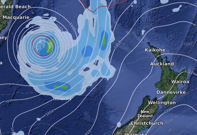 ABOVE: Ex-Cyclone Uesi this Friday night just offshore from the North Island as it heads south towards the West Coast of the South Island. Rain will miss the North Island.
BELOW: 10 days from now, Sun 23, another tropical low or storm likely, this time east of the North Island and again well offshore. Again, no rain but perhaps enhanced showers with east to south east winds.
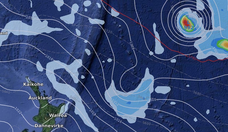
The second storm will be well east of NZ but the shape of the air pressure systems in 10 days time should encourage more showers in the east thanks to an enhanced E to SE wind. Showers may start to accumulate better totals, as you can see in the eastern side of the North Island rain map below. These showers may drift inland – or may help produce new inland downpours.
Finally, the humidity that will increase for some in the days ahead will also enhance the chance of some heavy afternoon downpours, mostly inland through the North Island and perhaps some into the upper South Island.
While we’re focused on as many positive as we can, it’s also worth stressing that the rest of February looks drier than average and that drought zones will get larger and more serious before February has finished.
15 DAY FORECAST RAINFALL FOR REST OF FEBRUARY – NORTH ISLAND:
15 DAY FORECAST RAINFALL FOR REST OF FEBRUARY – SOUTH ISLAND:

WHAT ABOUT MARCH?
At this stage WeatherWatch.co.nz expects the tropics to be highly active, with possibly two tropical lows to monitor and more sub-tropical showers drifting our way at the start of the month.
Here’s the extra long range map for March 1st, indicating how March will be kicking off. It shows two tropical storms (red arrows) and the enhanced area of sub-tropical showers/wet weather (yellow box). High pressure lies east of the North Island encouraging hotter north to north west airflows into the South Island.

– WeatherWatch.co.nz
Latest Video

Westerlies continue, sub-tropical for some
West to north-west winds blow through the South Island and lower North Island today bring heavy West Coast rain and…
Related Articles
Westerlies continue, sub-tropical for some
West to north-west winds blow through the South Island and lower North Island today bring heavy West Coast rain and…

Westerly change this week, unsettled but large dry areas
Westerlies kick back in again this week which will bring a break to those in the east as far as…

Matariki, the long weekend + the outlook for next week
Wet weather and cloud continues along the eastern side of the country with the heaviest rain now moving into northern…

