Cyclone Lusi may make landfall over Auckland (+6 maps)
11/03/2014 5:04am

> From the WeatherWatch archives
UPDATED 5:39pm Tuesday — Tropical Cyclone Lusi has been upgraded to a Category 2 cyclone this afternoon near Vanuatu with the Fiji Met Service predicting the storm will intensfy rapidly into a Cat3 storm.
The central air pressure is currently 985hPa and is expected to drop into the 960s range before reaching New Zealand.
Winds are currently averaging around 90km/h at the centre.
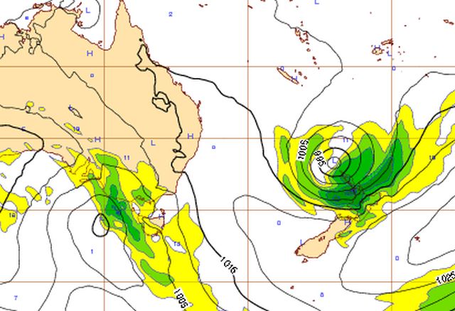
Overnight the computer models shifted the predicted path of Lusi closer towards New Zealand with a direct hit to the upper North Island looking increasingly likely for Saturday night.
Current data now suggests the centre of the storm may pass over our largest city, Auckland, overnight Saturday and into Sunday morning – this could also help fuel damaging winds to the eastern Waikato and Coromandel Peninsula, along with Northland and Auckland.
“Lusi looks like it could be a fairly intense storm when it reaches New Zealand this weekend. The most severe weather will be wrapped around the centre when it rolls in but many North Islanders can expect a windy and wet weekend” says head weather analyst Philip Duncan.
Rain or showers, along with brisk and strengthening easterlies, will push southwards across much of, if not the entire, North Island.
The exact path of the centre of Lusi is still unknown at this stage for New Zealand but the centre looks likely to cross somewhere around Auckland then will unwind over the North Island on Sunday – with rain easing in the north on Sunday morning.
If the low makes landfall in Auckland it could also lead to coastal storm surge flooding in vlunerable places.
Our updates will continue with multiple daily updates from now until at least Sunday PM.
– WeatherWatch.co.nz
MAPS as of Tuesday PM


Above/Below / JTWC

Above / Saturday morning / ECMWF
Below / Saturday morning / MetOcean 
Below / Latest Pacific Islands tracking map for Lusi, courtesy of Fiji Met

– WeatherWatch.co.nz
Comments
Latest Video

Cold weekend, frosts return with high pressure, then a low late next week
The subantarctic airflow spreads over NZ today/tonight and into Saturday, dropping temperatures nationwide. Snow flurries are possible today to lower…
Related Articles
Cold weekend, frosts return with high pressure, then a low late next week
The subantarctic airflow spreads over NZ today/tonight and into Saturday, dropping temperatures nationwide. Snow flurries are possible today to lower…

Wintry burst of weather: Snow, squally showers then sunshine & frosts
A polar change (another one!) arrives on Friday for the South Island and goes nationwide on Saturday, leaving NZ under…

Antarctic southerly for parts of NZ Fri & Sat
For the first time this year a southerly from off Antarctica is heading towards the South Island, followed by more…


Guest on 14/03/2014 9:06pm
Hiya, will Nelson be allgoods?
Marion Taniwha on 14/03/2014 9:30am
Hi could you tell me what the weather in Tauranga like,
Please reply?
Guest on 13/03/2014 8:16pm
I live in Devonport and am supposed to attend the evening session of Beer Fest tomorrow (4-10pm). What are the chances that the ferry service will be cancelled? I’m new to town so do not have experience with whether the ferries are ever cancelled.
WW Forecast Team on 13/03/2014 8:19pm
HI there – please see the lead story on our homepage about travel issues
Cheers
WW
Guest on 13/03/2014 8:20am
uh, oh. Flying domestically on a little turboprop plane from Auckland to Tauranga on Saturday evening. Hope i wont be affected and put on a bus or get stranded in Auckland.
Guest on 12/03/2014 10:29pm
HI were getting married on Satuday afternoon halfway between Paraparaumu and Waikanae.
Outdoor event – whats the prognosis – windy, rain later in the evening?
Thanks
WW Forecast Team on 12/03/2014 11:31pm
Hi there – winds will pick up as the day goes on and a chance of some late spits. Hopefully it will be later but it may arrive mid afternoon. Keep an eye on our Wellington forecast (we’re mentioning Kapiti coast at the moment) and the rain and wind maps at the top of the page.
Cheers and all the best for your special day! Not many NZers get married the day a cyclone is hitting.
– WW
Guest on 12/03/2014 10:18pm
Hi,
Can i ask if the cyclone will hit Gisborne? Thanks …
WW Forecast Team on 12/03/2014 11:33pm
It will brush Gisborne – could deliver some heavy rain and gale force winds for a time, but hopefully mostly below damaging threshold. Keep up to date as conditions may change.
– WW
View more comments