Cyclone Gita – Latest tracking starts to firm up a little more (+7 Maps)
17/02/2018 7:16am

> From the WeatherWatch archives
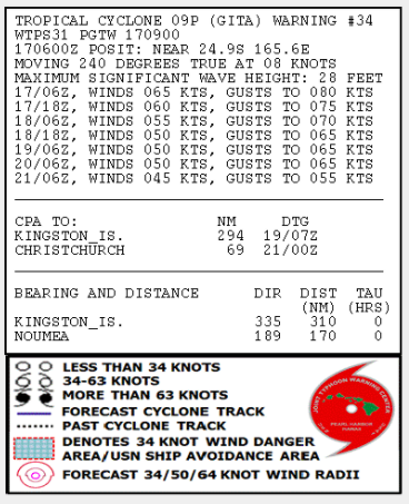
UPDATED 11:45pm Saturday — Cyclone Gita still remains a Severe Category 3 tropical storm as it moves into the northern Tasman Sea, although it is likely to drop to a Category 2 cyclone overnight.
Central air pressure has actually dropped a little today, from 973hPa this morning to 970hPa this evening. This is still well up from when it dropped to 927hPa as a Category 5 storm earlier in the week, but remains very deep and stormy for a low pressure system in the Tasman Sea.
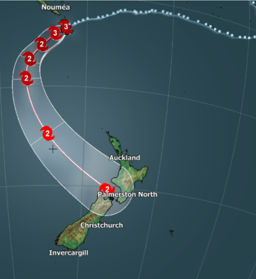
Here’s the latest tracking of #Gita courtesy, as always, to the US Government.

Gita still retains an eye, although it has weakened and fallen apart a bit today. This is the image taken this evening as sun was setting over it.

Gita remains an intense and serious storm with a huge amount of wind and rain around it – and a lot of tropical air. New Zealand is directly in the path of Cyclone Gita and today the models started to agree on where it might make landfall, but we still need more time to confirm things.
GFS (American modelling) has been picking a South Island landfall for days, while ECMWF (European) has been picking the western side of the North Island from Wellington and Taranaki to Waikato. Today both of these trusted global sources have gone with the upper north west corner of the South Island. Of course this isn’t yet locked in and with the storm still at least three days away this could definitely still change. However it does highlight that both main islands of New Zealand are at risk from flooding and wind damage. In the coming days we expect this to still shift around a bit northwards and southwards as it fine tunes the data.
Today Metservice significantly shifted their Severe Weather Outlook, removing the more North Island focus they had on Friday. MetService now says Gita will come in further south impacting more central areas which affects the upper South Island. This now aligns with what WeatherWatch.co.nz has been saying for the past two days, that a more central hit looks likely – this should help reduce confusion from some who were asking why we had quite different forecasts. Reliable modelling suggests landfall will be in the upper north west side of the South Island – we’ll be more confident about locking this in by Sunday evening or Monday morning at the latest.
Tracking from the Joint Typhoon Warning Center (US Government) says the gales will be expanding as it reaches New Zealand with their map showing gales are possible from as far south as Dunedin to as far north as Taranaki even Waitomo and Central Plateau maybe even Auckland. We expect a further update from them this evening.
Where the low makes landfall will help forecasters work out where the severe weather will most likely be. We need to lock in landfall before we can lock in precise severe weather risks and regions affected.
Computer models today say Cyclone Gita will have Category 2 strength when it arrives in New Zealand which means winds will be sustained at the centre between 89 and 117km/h. It may weaken quite fast when it hits the South Island’s Southern Alps.
Gita has started the southerly turn to New Zealand which will take all weekend to stop the westwards movement. It’s now tracking SW. For the past few days it’s been tracking westwards. As of 8pm Saturday Gita was located 1550kms NW of Auckland, New Zealand.
There remains a lot of uncertainty about where the severe weather will be but all this past week guidance has suggested the upper South Island could experience very heavy rain. Damaging winds could extend for hundreds of kilometres from the centre of Gita. Because of this central tracking through New Zealand it means there could be issues in both islands. Travel delays are also likely, from motorists to air travellers to those crossing Cook Strait. Expect cancellations of some services early to mid next week if Gita holds on to the strength it has.
The storm is expected to bring waves of 12 metres and higher near the centre which could lead to significant coastal damage and flooding where the centre of Gita comes in.
Due to so much uncertainty with the models it will most likely be until Monday before exact location of landfall is worked out. Certainly central New Zealand (upper half of the South Island and lower half of the North Island) appears to be at the greatest risk based on the past few days of various models – but this could still shift further north or south. We’ll keep you posted on what the models are saying in the days ahead but all New Zealanders need to be watching this closely.
Both GFS and ECMWF models suggest Cyclone Gita will arrive on Tuesday afternoon and overnight into Wednesday morning. What happens at that point is still not locked in either. It’s becomes a much more complicated low by the time it reaches New Zealand which is why there is still uncertainty.
 – Wave heights / The Weather Company
 – Fiji Met Service
 ABOVE – ECMWF MAP FOR TUESDAY EVENING
BELOW – GFS MAP FOR TUEDAY EVENING
– WeatherWatch.co.nz
Comments
Latest Video

NZ: 8 Day outlook as gales & rain ease, high pressure builds
Damaging wind gusts and heavy rain will continue to affect some parts of the North Island and brushing Marlborough today…
Related Articles
NZ: 8 Day outlook as gales & rain ease, high pressure builds
Damaging wind gusts and heavy rain will continue to affect some parts of the North Island and brushing Marlborough today…

Pockets of hit & miss heavy rain, snow moves northwards
Low pressure continues to slowly move across the upper North Island and for some that will bring the sun out,…

Slow go for northern low & southern cold
For the next few days low pressure will crawl over the upper North Island, driving in rain as far south…


Tim on 19/02/2018 7:13pm
Hello,
We have to leave our accommodation near Mount Lyford at 10am Wednesday and need to drive to Nelson that day… is this safe?
Thanks,
Tim
WW Forecast Team on 19/02/2018 8:20pm
Our advice is to stay put with the cyclone coming in, especially if you don’t know the area well. In saying that, the worst comes in later this afternoon and evening. Ask some locals around you, they will be helpful to guide you too.
Stay safe!
Cheers
WW
Guest on 19/02/2018 3:36am
Hi Guys,
Thankyou for your running commentary.
How locked in is TC Gita’s present path? I’m in Auckland and everyone seems to think we will be totally unaffected. However, from what I understand predictive models are just that and cyclones can change direction at any time.
So do you think that, at this stage, that the models will hold or could we see some deviations?
WW Forecast Team on 19/02/2018 4:36am
Hi there – Auckland could have gale force winds on Tuesday afternoon in some areas with gusts in very exposed places to 90km/h. But the bulk of the energy is further south. Everyone in NZ needs to be on alert about Gita, it’s not often all of the country is under a risk from a tropical storm but in this case it’s growing in size (not strength) as it moves in and crossing much warmer than average waters. It could still move – but the most likely path is the top of the South Island/Cook Strait (for the centre) with the worst winds extending out for 200 to 300kms from that centre.
We’ll be fine tuning on Tuesday morning before it arrives.
Cheers and thanks for the thanks! 🙂
– WW
Guest on 18/02/2018 9:34am
Can you please tell me if New Plymouth will be affected thanks
WW Forecast Team on 18/02/2018 9:40am
Hi there, please see the last two news stories on our home page for more details. Taranaki is certainly exposed to this storm.
Cheers
WW
Guest on 18/02/2018 2:09am
Is this expected to cause any delays to flights at all? We are set to fly Auckland to Melbourne on Tuesday evening
WW Forecast Team on 18/02/2018 2:15am
Hi there, at this stage we don’t expect much impact to flights to/from Auckland International Airport. Domestic fights will have more risks for delays and cancellations, especially services flying in from/out of the central part of NZ (lower North Island, upper South Island).
Cheers
WW
View more comments