Cyclone Gita: A tricky twist in the forecast, plus more FAQs (+10 Maps)
17/02/2018 10:53pm

> From the WeatherWatch archives
Extensive Coverage — Cyclone Gita is now a strong Category 2 Tropical Cyclone with central air pressure of 975hPa and continues to track SW – but is turning southerly towards New Zealand and will weaken a little further today as it does that. This small weakening could see sustained winds dropping from 111km/h to 93km/h. Remember this is out at sea – when it enters the New Zealand terrain the mountains and ranges will block these winds for some, ramp them up much more for others, as we see with any storm that affects us.
WHAT IS HAPPENING TODAY, SUNDAY?
There has certainly been another further jog southwards in the thinking today on where the worst of this storm will be next week. Remember while all of New Zealand is currently at risk of being affected by Cyclone Gita the worst of the winds covers an area of 900kms in diameter. This means around half of New Zealand should be on the outside of the worst part.
The models we rely on – and there are many, but we do boil it down to the two main ones GFS and ECMWF (America and Europe) to avoid being lost in the forest for the trees – are suggesting a South Island hit with the upper North Island looking least exposed, but still somewhat exposed. Again there could be a last minute change that sees it swing back closer to the upper North Island – so everyone in New Zealand should be keeping up with the latest tracking from WeatherWatch.co.nz and the NZ MetService.
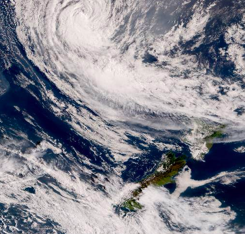
– Himawari satellite from mid Sunday morning shows Gita to the north and outflow clouds spreading over northern New Zealand.
A TWIST IN THE FORECAST
It’s one thing trying to work out where a storm will make landfall – it’s an entirely other thing to work out how the weather will behave when the storm splits into pieces, as modelling suggests Gita will do when it hits the Southern Alps on Tuesday night.
The centre of the low could split into two other centres – tearing the storm apart quite quickly and spreading the energy much further afield – so instead of super intense wind and rain within a few hundred kms it may push more ‘normal’ windy and wet weather out and across.
Perfectly working out which areas are most exposed to the worst winds and heavy rain is proving to be tricky due to the storm looking like it will quickly fall apart overnight Tuesday and into Wednesday.
HOW SOUTH WILL GITA GO BEFORE LOSING “TROPICAL CYCLONE” status?
Regardless of if it technically is still a “tropical” warm core cyclone as it gets closer to NZ or not the winds appear to be low end Category 2 status for some time, then likely Category 1 status as it makes landfall. Gusts could be much higher due to the terrain, in fact 200km/h gusts are likely in the mountains where the storm hits. This is not in main centres but in main centres winds could be 60 to 100km/h with gusts higher.

Last night National Institute of Water and Atmospheric Research meteorologist Ben Noll said it may retain that “tropical” title until landfall. It’s hard to prove or disprove though, with such limited data available in New Zealand.
This morning the Joint Typhoon Warning center says it will be extra-tropical by landfall – but it may be doing this transition further south than most other storms, especially when you consider how much further south the South Island is compared to northern Northland or East Cape where the majority of tropical storms usually come in to.
Although Tropical #CycloneGita is leaving the tropics, it may well remain a warm-core system right up until landfall in New Zealand on Tuesday, with very warm SSTs playing a role — significant impacts are expected. pic.twitter.com/w4pUjldrVz
— Ben Noll (@BenNollWeather) February 17, 2018
This isn’t the main thing to focus on though – once Gita gets a cold core (as it moves towards the NW South Island) it will then transition fully into an extra-tropical cyclone and that’s when it becomes a bigger system but not so intense around the centre. A lot of this will happen over the South Island and central New Zealand overnight Tuesday/Wednesday AM by the looks of it. The storm may “technically” lose its tropical cyclone status before New Zealand while it’s well out at sea – but that may not mean there is any real impact on the speeds of the winds at the centre – it simply refers to the fact the core of the storm is moving from warm air to cold air which generally takes a couple of days to happen.
WHICH AREAS LOOK WORST AFFECTED?
At the moment the West Coast, the Southern Alps (especially the northern half) and the upper South Island. Rain, heavy at times, may also spread into the eastern South Island for 24 hours. The lower and western North Island is also exposed – and as the low morphs into a new system other regions might be impacted that currently aren’t highlighted.
HOW FAR COULD WARNINGS SPREAD?
Yesterday in MetService’s once a day Severe Weather Outlook (SWO) they indicated that central NZ and the upper and western South Island were most at risk. The low could brush close enough even to northern New Zealand for gales for a time – but the models aren’t on the same page about this which is why confidence is low. But the fact that the areas below are highlighted means everyone within them should be well aware of the incoming weather. Their next SWO update will be this afternoon and may shift further south still. 
WHERE WILL THE WORST WINDS AND RAIN BE?
Due to the fact this storm is expected to split up when it hits the South Island mountains it’s making it very tricky to be precise. Based on modelling today (Sunday) for Tuesday PM and Wednesday it looks as though the worst winds will be in the Southern Alps, West Coast and Cook Strait area (lower North Island, upper South Island). It may also be windy along the North Island’s west coast as far north as Auckland and Northland. Rain will be heaviest over the South Island – we’ll get more specific on Monday.
IS GITA GOING TO BE A REPEAT OF GISELLE OR BOLA?
No two cyclones are the same – they are as unique as human beings are. We continue to share that advice because people are frequently asking us to compare Gita against other storms like Bola or Giselle. Cyclone Gita is following a similar track to recent Cyclone Fehi now but is more powerful – and with landfall expected on the West Coast it is creating some similarities to Fehi – but again it’s still a different beast and will do different things. Those directly in the path of the storm should be prepared for floods, slips, power cuts, road closures and wind damage. Big seas and damaging waves will also cause coastal flooding and damage directly where the centre of the storm comes in, which still looks to be the north western corner of the South Island on Tuesday night – this could still change.
Also, you can’t compare a cyclone to previous ones until it has already passed and ‘done its thing’. Quite often there are just too many moving parts to compare storms beforehand.
BY WEDNESDAY GITA COULD BE TWICE THE SIZE BUT LESS SEVERE
On Tuesday Cyclone Gita will be a powerful cyclone in the Tasman Sea. By Wednesday it may be twice as wide due to developing at least two centres on either side of the South Island – but this action greatly spreads the energy and could make for calm weather in places where people are expecting gales. The fact the storm centre will split in two means forecasters will be dealing with a very different system just 12 hours after Gita first arrived.
This splitting up of the energy means others areas away from the original place of landfall could be impacted by some severe weather – so this is why almost all New Zealanders need to closely monitor what is happening.
It’s a very complicated set up.
WHAT IS HAPPENING TODAY TO GITA?
It should remain as a Category 2 tropical cyclone in the Tasman Sea and start turning more southwards directly.
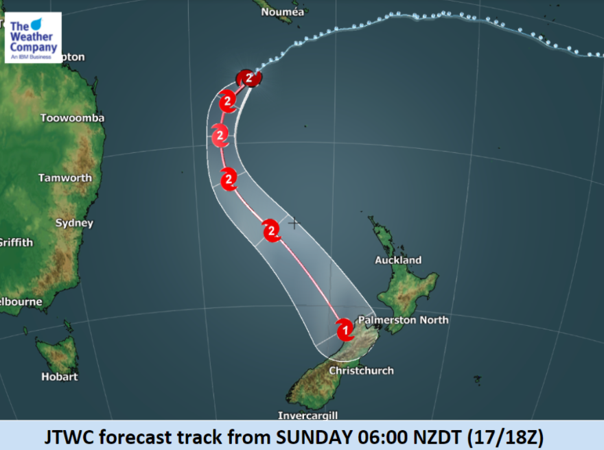
WHAT IS THE LATEST TRACKING?
The Joint Typhoon Warning Center (US Government) updates future tracking maps four times a day. MetService’s tax funded map is once a day, in the afternoons.
JTWC is currently showing this as the main central tracking of the storm. This is a little bit weaker than what it was showing overnight.


WHAT THE MODELS ARE NOW SAYING:
We compare GFS (America) with ECMWF (Europe) as Gita comes in.
We show two maps from each model, 6pm Tuesday and then 12 hours later at 6am Wednesday
GFS – 6PM TUESDAY:
GFS – 6AM WEDNESDAY:
ECMWF – 6PM TUESDAY:
ECMWF – 6AM WEDNESDAY:
- Please keep up to date with WeatherWatch.co.nz forecasts, news, videos (returning Monday) and tracking maps of Cyclone Gita.
- Also, your taxes help fund MetService‘s rain radar and provide weather warnings – please keep up to date with the latest on Gita from this Government Agency, especially the official warnings they will be issuing for this event closer to the time.
- Another helpful source is Lert.info for nationwide and/or very local emergency information from various authorities.
– WeatherWatch.co.nz
Comments
Latest Video

Matariki, the long weekend + the outlook for next week
Wet weather and cloud continues along the eastern side of the country with the heaviest rain now moving into northern…
Related Articles
Matariki, the long weekend + the outlook for next week
Wet weather and cloud continues along the eastern side of the country with the heaviest rain now moving into northern…

More eastern rain, but a drier long weekend coming
Rain continues today along the eastern South Island and lower North Island, coming in from the east with heavy falls….

More heavy rain, snow – but large dry areas, especially as we go into the long weekend
Heavy rain will continue for parts of Canterbury and Marlborough over the next day or two and it will gradually…


Guest on 18/02/2018 6:22am
Is this going to affect Auckland and Northland at all??
2 weeks ago it was said that they would be a direct hit.
WW Forecast Team on 18/02/2018 9:15am
No one said two weeks ago it was going to be a direct hit to Northland and Auckland (that we are aware of anyway). The story in the media said NZ could be directly hit. Auckland and Northland appear to be too far north – but do have some risks. We’ll have more details on Monday – and take a look at our new 10pm story up on our news feed now.
Cheers
WW
View more comments